– Lat/Long: 44.42° N 121.88° W
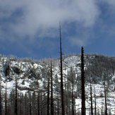
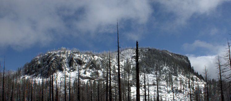
 Hogg Rock
Weather Forecast, United StatesIssued: 4 am Mon 03 Aug Local TimeUpdates in: hr min sUpdate imminent
Issued: 4 am Mon 03 Aug Local Time
Updates in:
Update imminent hr min s

Issued: 4 am Mon 03 Aug Local Time
Updates in:
Update imminent hr min s
Days 1–3 Weather SummaryMostly dry. Warm (max 27°C on Wed afternoon, min 9°C on Mon morning). Wind will be generally light. | Days 4–6 Weather SummaryMostly dry. Warm (max 26°C on Thu afternoon, min 13°C on Sat night). Mainly fresh winds. | |||||||||||||||||
Monday 3 | Tuesday 4 | Wednesday 5 | Thursday 6 | Friday 7 | Saturday 8 | |||||||||||||
AM | PM | night | AM | PM | night | AM | PM | night | AM | PM | night | AM | PM | night | AM | PM | night | |
clear | clear | clear | clear | clear | clear | clear | clear | clear | clear | clear | clear | clear | clear | clear | clear | clear | clear | |
Cloud base (m) | 9550 | 8500 | ||||||||||||||||
km/h | ||||||||||||||||||
 |  |  |  |  |  | |||||||||||||
— | — | — | — | — | — | — | — | — | — | — | — | — | — | — | — | — | — | |
mm | — | — | — | — | — | — | — | — | — | — | — | — | — | — | — | — | — | — |
max °C | 14 | 20 | 18 | 20 | 26 | 23 | 24 | 27 | 23 | 25 | 26 | 21 | 20 | 22 | 17 | 18 | 21 | 17 |
min °C | 9 | 18 | 15 | 16 | 24 | 21 | 21 | 27 | 21 | 21 | 25 | 16 | 16 | 21 | 14 | 15 | 21 | 13 |
chill °C | 7 | 18 | 15 | 16 | 24 | 21 | 21 | 27 | 21 | 21 | 25 | 16 | 16 | 21 | 14 | 15 | 21 | 12 |
Freezing level m | 4400 | 4500 | 4700 | 4750 | 4800 | 4950 | 4950 | 5050 | 5150 | 4950 | 5000 | 4950 | 4700 | 4850 | 4900 | 4750 | 4750 | 4750 |
5:56 | — | — | 5:56 | — | — | 5:58 | — | — | 5:58 | — | — | 6:00 | — | — | 6:01 | — | — | |
— | — | 8:30 | — | — | 8:29 | — | — | 8:27 | — | — | 8:25 | — | — | 8:23 | — | — | 8:22 | |
Loading...
Hogg Rock Weather (Days 0-3):
The weather forecast for Hogg Rock is: Mostly dry. Warm (max 27°C on Wed afternoon, min 9°C on Mon morning). Wind will be generally light.
Hogg Rock Weather (Days 3-6):
Mostly dry. Warm (max 26°C on Thu afternoon, min 13°C on Sat night). Mainly fresh winds.
This table gives the weather forecast for Hogg Rock at the specific elevation of 1551 m. Our advanced weather models allow us to provide distinct weather forecasts for several elevations of Hogg Rock. To see the weather forecasts for the other elevations, use the tab navigation above the table. For a wider overview of the weather, consult the Weather Map of Oregon.