– Lat/Long: 61.37° N 8.10° E
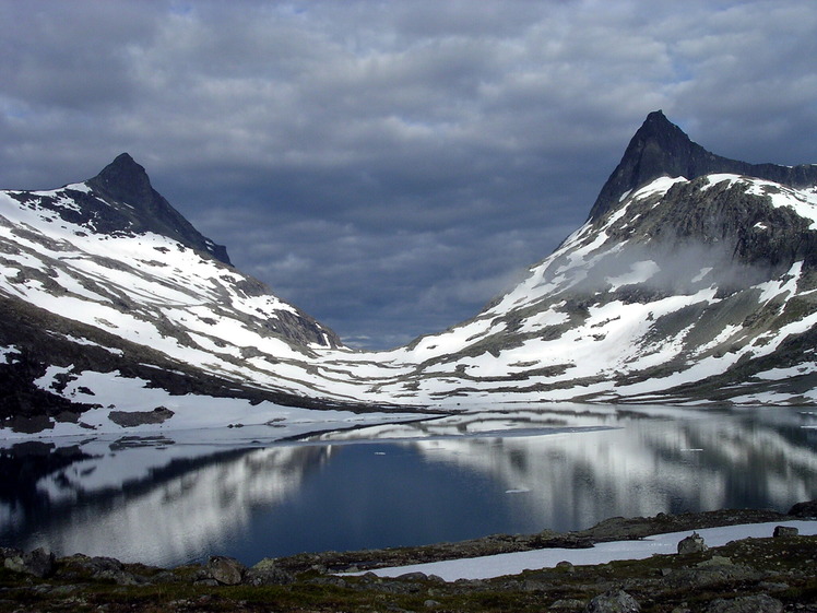
 Hjelledalstind
Weather Forecast, NorwayIssued: 7 am Mon 03 Aug Local TimeUpdates in: hr min sUpdate imminent
Issued: 7 am Mon 03 Aug Local Time
Updates in:
Update imminent hr min s

Issued: 7 am Mon 03 Aug Local Time
Updates in:
Update imminent hr min s
Days 1–3 Weather SummaryHeavy rain (total 21mm), heaviest during Wed night. Freeze-thaw conditions (max 6°C on Tue afternoon, min -2°C on Mon morning). Wind will be generally light. | Days 4–6 Weather SummaryModerate rain (total 17mm), heaviest on Thu morning. Freeze-thaw conditions (max 4°C on Fri afternoon, min -1°C on Sat night). Winds increasing (light winds from the NW on Fri morning, fresh winds from the SW by Sat afternoon). | |||||||||||||||||
Monday 3 | Tuesday 4 | Wednesday 5 | Thursday 6 | Friday 7 | Saturday 8 | |||||||||||||
AM | PM | night | AM | PM | night | AM | PM | night | AM | PM | night | AM | PM | night | AM | PM | night | |
cloudy | some clouds | some clouds | some clouds | some clouds | light rain | light rain | light rain | rain shwrs | heavy rain | light rain | rain shwrs | some clouds | rain shwrs | rain shwrs | cloudy | light rain | some clouds | |
Cloud base (m) | 850 | 900 | 1600 | 1700 | 2450 | 1900 | 1550 | 1500 | 800 | 750 | 750 | 1600 | 1900 | 2300 | 2050 | 2400 | 800 | 800 |
km/h | ||||||||||||||||||
 |  |  |  |  |  | |||||||||||||
— | — | — | — | — | — | — | — | — | — | — | — | — | — | — | — | — | — | |
mm | — | — | — | — | — | 4 | 0.1 | 0.8 | 16 | 11 | 4 | 0.6 | — | 0.1 | 0.1 | — | 0.3 | — |
max °C | -2 | 0 | 0 | 3 | 6 | 6 | 5 | 6 | 6 | 3 | 3 | 3 | 3 | 4 | 3 | 3 | 2 | 0 |
min °C | -2 | -1 | -1 | 0 | 5 | 3 | 4 | 6 | 4 | 3 | 3 | 2 | 2 | 4 | 0 | 1 | 1 | -1 |
chill °C | -9 | -7 | -5 | -3 | 2 | 0 | 1 | 4 | 4 | 1 | -1 | 0 | 0 | 2 | -4 | -3 | -4 | -7 |
Freezing level m | 1700 | 1950 | 1750 | 2550 | 2700 | 2800 | 3000 | 3100 | 2900 | 2550 | 2550 | 2500 | 2450 | 2400 | 2150 | 2400 | 2250 | 1950 |
5:01 | — | — | 5:03 | — | — | 5:07 | — | — | 5:09 | — | — | 5:11 | — | — | 5:15 | — | — | |
— | — | 10:02 | — | — | 10:00 | — | — | 9:58 | — | — | 9:54 | — | — | 9:52 | — | — | 9:49 | |
Loading...
Hjelledalstind Weather (Days 0-3):
The weather forecast for Hjelledalstind is: Heavy rain (total 21mm), heaviest during Wed night. Freeze-thaw conditions (max 6°C on Tue afternoon, min -2°C on Mon morning). Wind will be generally light.
Hjelledalstind Weather (Days 3-6):
Moderate rain (total 17mm), heaviest on Thu morning. Freeze-thaw conditions (max 4°C on Fri afternoon, min -1°C on Sat night). Winds increasing (light winds from the NW on Fri morning, fresh winds from the SW by Sat afternoon).
This table gives the weather forecast for Hjelledalstind at the specific elevation of 1989 m. Our advanced weather models allow us to provide distinct weather forecasts for several elevations of Hjelledalstind. To see the weather forecasts for the other elevations, use the tab navigation above the table. For a wider overview of the weather, consult the Weather Map of Norway.
| Weather Station | Temp. | Weather | Wind | Gusts | Cloud / Visibility |
|---|---|---|---|---|---|
Filefjell | |||||
Beitostolen II | |||||
Modvaberget | |||||
OPK Grøndalen | |||||
Sogndal AP | |||||
Tylderingen | |||||
Volbufjorden | |||||
Brata -Slettom |
* NOTE: not all weather observatories update at the same frequency which is the reason why some locations may show data from stations that are further away than known closer ones.
Hjelledalstind Photos
View all
Jotunheimen photos (3) |
Scandinavia/European Arctic Ranges photos (16) |
photos from mountains in Norway (115) |
all photos
 Upload new photo
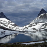
Hjelledalstind