– Lat/Long: 68.36° N 14.79° E
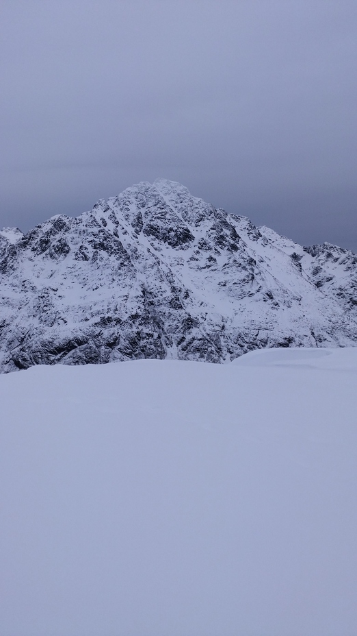
 Higravstinden
Weather Forecast, NorwayIssued: 1 pm Tue 28 Jul Local TimeUpdates in: hr min sUpdate imminent
Issued: 1 pm Tue 28 Jul Local Time
Updates in:
Update imminent hr min s

Issued: 1 pm Tue 28 Jul Local Time
Updates in:
Update imminent hr min s
Days 1–4 Weather SummaryModerate rain (total 11mm), heaviest on Tue night. Very mild (max 13°C on Fri morning, min 8°C on Wed afternoon). Wind will be generally light. | Days 5–7 Weather SummaryModerate rain (total 13mm), heaviest on Fri night. Very mild (max 13°C on Fri afternoon, min 6°C on Sun night). Winds decreasing (strong winds from the SW on Fri night, calm by Sat night). | ||||||||||||||||
Tue 28 | Wednesday 29 | Thursday 30 | Friday 31 | Saturday 1 | Sunday 2 | ||||||||||||
PM | night | AM | PM | night | AM | PM | night | AM | PM | night | AM | PM | night | AM | PM | night | |
light rain | light rain | light rain | light rain | rain shwrs | cloudy | cloudy | some clouds | rain shwrs | light rain | mod. rain | light rain | light rain | rain shwrs | cloudy | rain shwrs | rain shwrs | |
Cloud base (m) | 2200 | 50 | 50 | 100 | 5900 | 2350 | 900 | 1450 | 1850 | 250 | 100 | 200 | 650 | 1600 | 1600 | 600 | 900 |
km/h | |||||||||||||||||
 |  |  |  |  |  | ||||||||||||
— | — | — | — | — | — | — | — | — | — | — | — | — | — | — | — | — | |
mm | 0.8 | 5 | 1.5 | 1.5 | 1.4 | — | — | — | 0.3 | 3 | 7 | 1.3 | 1.4 | 0.2 | — | 0.4 | 0.4 |
max °C | 11 | 10 | 9 | 9 | 9 | 12 | 12 | 11 | 13 | 13 | 8 | 7 | 8 | 8 | 8 | 9 | 8 |
min °C | 11 | 9 | 9 | 8 | 8 | 10 | 11 | 11 | 13 | 10 | 8 | 7 | 8 | 8 | 8 | 9 | 6 |
chill °C | 10 | 7 | 7 | 5 | 5 | 9 | 10 | 11 | 12 | 6 | 3 | 2 | 4 | 6 | 7 | 8 | 3 |
Freezing level m | 2300 | 2200 | 2100 | 2000 | 2350 | 2700 | 2600 | 2750 | 2850 | 2700 | 1750 | 1450 | 1600 | 1700 | 1700 | 1700 | 1500 |
— | — | 2:47 | — | — | 2:54 | — | — | 3:00 | — | — | 3:04 | — | — | 3:11 | — | — | |
— | 11:27 | — | — | 11:21 | — | — | 11:15 | — | — | 11:08 | — | — | 11:04 | — | — | 10:58 | |
Loading...
Higravstinden Weather (Days 0-3):
The weather forecast for Higravstinden is: Moderate rain (total 11mm), heaviest on Tue night. Very mild (max 13°C on Fri morning, min 8°C on Wed afternoon). Wind will be generally light.
Higravstinden Weather (Days 3-6):
Moderate rain (total 13mm), heaviest on Fri night. Very mild (max 13°C on Fri afternoon, min 6°C on Sun night). Winds decreasing (strong winds from the SW on Fri night, calm by Sat night).
This table gives the weather forecast for Higravstinden at the specific elevation of 500 m. Our advanced weather models allow us to provide distinct weather forecasts for several elevations of Higravstinden. To see the weather forecasts for the other elevations, use the tab navigation above the table. For a wider overview of the weather, consult the Weather Map of Norway.
| Weather Station | Temp. | Weather | Wind | Gusts | Cloud / Visibility |
|---|---|---|---|---|---|
Svolvær lufthav / elle Airport | |||||
Skrova LH | |||||
Rotvaer | |||||
Håfjell.Alpinservice | |||||
Evenes AP | |||||
Harstad Modellflyklu | |||||
HPGT Samaåsen |
* NOTE: not all weather observatories update at the same frequency which is the reason why some locations may show data from stations that are further away than known closer ones.
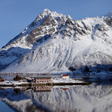
Higravstinden Photos
View all
photos (8) |
Scandinavia/European Arctic Ranges photos (16) |
photos from mountains in Norway (115) |
all photos
 Upload new photo
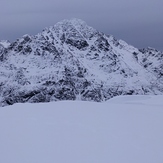
Higravstinden
Higravstinden