– Lat/Long: 45.17° N 109.80° W
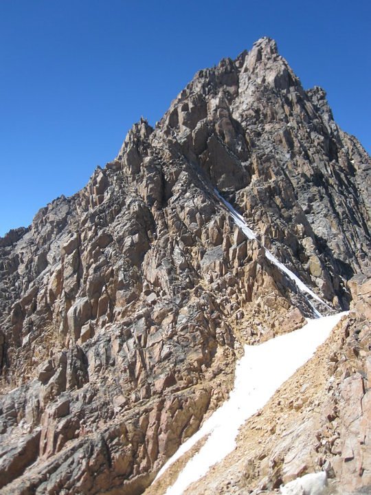
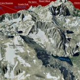
 Granite Peak (Montana)
Weather Forecast, United StatesIssued: 5 am Mon 03 Aug Local TimeUpdates in: hr min sUpdate imminent
Issued: 5 am Mon 03 Aug Local Time
Updates in:
Update imminent hr min s

Issued: 5 am Mon 03 Aug Local Time
Updates in:
Update imminent hr min s
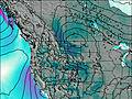
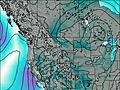
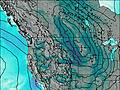
Days 1–3 Weather SummaryMostly dry. Very mild (max 16°C on Wed afternoon, min 3°C on Mon morning). Wind will be generally light. | Days 4–6 Weather SummaryMostly dry. Warm (max 21°C on Fri afternoon, min 13°C on Thu morning). Winds decreasing (near gales from the W on Fri afternoon, calm by Sat night). | |||||||||||||||||
Monday 3 | Tuesday 4 | Wednesday 5 | Thursday 6 | Friday 7 | Saturday 8 | |||||||||||||
AM | PM | night | AM | PM | night | AM | PM | night | AM | PM | night | AM | PM | night | AM | PM | night | |
clear | clear | clear | some clouds | some clouds | clear | clear | clear | clear | clear | clear | clear | clear | cloudy | rain shwrs | clear | clear | clear | |
Cloud base (m) | 4200 | 5700 | 4900 | 6300 | 6000 | |||||||||||||
km/h | ||||||||||||||||||
 |  |  |  |  |  | |||||||||||||
— | — | — | — | — | — | — | — | — | — | — | — | — | — | — | — | — | — | |
mm | — | — | — | — | — | — | — | — | — | — | — | — | — | — | 0.1 | — | — | — |
max °C | 6 | 8 | 4 | 8 | 11 | 9 | 12 | 16 | 14 | 15 | 19 | 18 | 18 | 21 | 18 | 16 | 19 | 16 |
min °C | 3 | 8 | 3 | 4 | 10 | 9 | 9 | 15 | 13 | 13 | 18 | 16 | 17 | 17 | 14 | 14 | 19 | 14 |
chill °C | 1 | 6 | 2 | 3 | 8 | 9 | 8 | 14 | 13 | 12 | 18 | 16 | 17 | 15 | 14 | 13 | 18 | 13 |
Freezing level m | 3550 | 4000 | 3450 | 3600 | 4350 | 4250 | 4350 | 4900 | 4800 | 4800 | 5200 | 5150 | 5150 | 5300 | 5100 | 4900 | 5250 | 5050 |
6:05 | — | — | 6:07 | — | — | 6:07 | — | — | 6:09 | — | — | 6:09 | — | — | 6:11 | — | — | |
— | 8:44 | — | — | 8:42 | — | — | 8:40 | — | — | 8:39 | — | — | 8:37 | — | — | 8:37 | — | |
Loading...
Granite Peak (Montana) Weather (Days 0-3):
The weather forecast for Granite Peak (Montana) is: Mostly dry. Very mild (max 16°C on Wed afternoon, min 3°C on Mon morning). Wind will be generally light.
Granite Peak (Montana) Weather (Days 3-6):
Mostly dry. Warm (max 21°C on Fri afternoon, min 13°C on Thu morning). Winds decreasing (near gales from the W on Fri afternoon, calm by Sat night).
This table gives the weather forecast for Granite Peak (Montana) at the specific elevation of 3000 m. Our advanced weather models allow us to provide distinct weather forecasts for several elevations of Granite Peak (Montana). To see the weather forecasts for the other elevations, use the tab navigation above the table. For a wider overview of the weather, consult the Weather Map of Montana.
| Weather Station | Temp. | Weather | Wind | Gusts | Cloud / Visibility |
|---|---|---|---|---|---|
Livingston Airport | |||||
Yellowstone Lake | |||||
Powell Municipal Airport (Wyoming) | |||||
Cody Airport |
* NOTE: not all weather observatories update at the same frequency which is the reason why some locations may show data from stations that are further away than known closer ones.
Granite Peak (Montana) Photos
View all
Beartooth Mountains photos (5) |
Rocky Mountains (USA) photos (298) |
photos from mountains in United States (3056) |
all photos
 Upload new photo
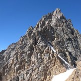
Before the snow bridge
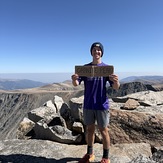
Granite Peak 9-6-25
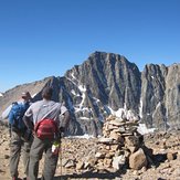
Before the saddle
Granite Peak (Montana)