– Lat/Long: 48.91° N 113.67° W
 Gable Mountain
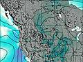
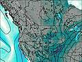
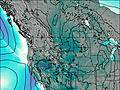
Weather Forecast, United StatesIssued: 11 pm Thu 23 Jul Local TimeUpdates in: hr min sUpdate imminent
Issued: 11 pm Thu 23 Jul Local Time
Updates in:
Update imminent hr min s

Issued: 11 pm Thu 23 Jul Local Time
Updates in:
Update imminent hr min s
Days 1–4 Weather SummaryMostly dry. Very mild (max 16°C on Sat afternoon, min 10°C on Sun morning). Winds increasing (fresh winds from the SW on Sat morning, severe gales from the WSW by Sat night). | Days 5–7 Weather SummaryMostly dry. Very mild (max 13°C on Tue afternoon, min 8°C on Mon night). Winds increasing (light winds from the WSW on Tue morning, gales from the WSW by Wed morning). | ||||||||||||||||||
Friday 24 | Saturday 25 | Sunday 26 | Monday 27 | Tuesday 28 | Wednesday 29 | ||||||||||||||
night | AM | PM | night | AM | PM | night | AM | PM | night | AM | PM | night | AM | PM | night | AM | PM | night | |
clear | clear | clear | clear | clear | clear | clear | clear | clear | clear | clear | clear | clear | clear | clear | clear | clear | clear | clear | |
Cloud base (m) | |||||||||||||||||||
km/h | |||||||||||||||||||
 |  |  |  |  |  |  | |||||||||||||
— | — | — | — | — | — | — | — | — | — | — | — | — | — | — | — | — | — | — | |
mm | — | — | — | — | — | — | — | — | — | — | — | — | — | — | — | — | — | — | — |
max °C | 14 | 11 | 14 | 13 | 14 | 16 | 13 | 11 | 12 | 12 | 11 | 12 | 10 | 10 | 13 | 12 | 10 | 10 | 9 |
min °C | 11 | 11 | 14 | 12 | 14 | 15 | 11 | 10 | 12 | 10 | 10 | 11 | 8 | 10 | 12 | 10 | 9 | 10 | 7 |
chill °C | 6 | 7 | 11 | 8 | 12 | 13 | 6 | 6 | 8 | 6 | 7 | 7 | 3 | 8 | 10 | 6 | 4 | 6 | 4 |
Freezing level m | 4700 | 4500 | 4750 | 4750 | 4800 | 4900 | 4750 | 4550 | 4550 | 4700 | 4300 | 4450 | 4350 | 4400 | 4450 | 4650 | 4250 | 4300 | 4300 |
— | 5:56 | — | — | 5:58 | — | — | 5:58 | — | — | 6:00 | — | — | 6:01 | — | — | 6:03 | — | — | |
— | — | — | 9:23 | — | — | 9:22 | — | — | 9:22 | — | — | 9:20 | — | — | 9:19 | — | — | 9:17 | |
Loading...
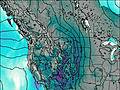
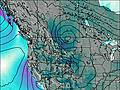
Gable Mountain Weather (Days 0-3):
The weather forecast for Gable Mountain is: Mostly dry. Very mild (max 16°C on Sat afternoon, min 10°C on Sun morning). Winds increasing (fresh winds from the SW on Sat morning, severe gales from the WSW by Sat night).
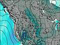
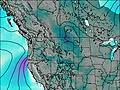
Gable Mountain Weather (Days 3-6):
Mostly dry. Very mild (max 13°C on Tue afternoon, min 8°C on Mon night). Winds increasing (light winds from the WSW on Tue morning, gales from the WSW by Wed morning).
This table gives the weather forecast for Gable Mountain at the specific elevation of 2823 m. Our advanced weather models allow us to provide distinct weather forecasts for several elevations of Gable Mountain. To see the weather forecasts for the other elevations, use the tab navigation above the table. For a wider overview of the weather, consult the Weather Map of Montana.
| Weather Station | Temp. | Weather | Wind | Gusts | Cloud / Visibility |
|---|---|---|---|---|---|
Carway- Alta | |||||
Waterton Park Gate- Alta | |||||
Bullhorn Headwaters- Alta | |||||
Cardston- Alta | |||||
Bullhorn Coulee Reservoir- Alta | |||||
Glenwood- Alta | |||||
Del Bonita Agdm- Alta |
* NOTE: not all weather observatories update at the same frequency which is the reason why some locations may show data from stations that are further away than known closer ones.