
– Lat/Long: 44.87° N 110.55° W
 Folsom Peak
Weather Forecast, United StatesIssued: 11 pm Thu 18 Jun Local TimeUpdates in: hr min sUpdate imminent
Issued: 11 pm Thu 18 Jun Local Time
Updates in:
Update imminent hr min s

Issued: 11 pm Thu 18 Jun Local Time
Updates in:
Update imminent hr min s
Days 1–4 Weather SummaryLight rain (total 8mm), mostly falling on Sat afternoon. Warm (max 22°C on Fri afternoon, min 7°C on Thu night). Wind will be generally light. | Days 5–7 Weather SummaryLight rain (total 5mm), mostly falling on Sun night. Warm (max 25°C on Wed afternoon, min 9°C on Sun night). Winds increasing (calm on Mon night, strong winds from the SW by Wed afternoon). | ||||||||||||||||||
Friday 19 | Saturday 20 | Sunday 21 | Monday 22 | Tuesday 23 | Wednesday 24 | ||||||||||||||
night | AM | PM | night | AM | PM | night | AM | PM | night | AM | PM | night | AM | PM | night | AM | PM | night | |
clear | cloudy | some clouds | some clouds | light rain | rain shwrs | rain shwrs | some clouds | rain shwrs | rain shwrs | rain shwrs | rain shwrs | clear | clear | clear | some clouds | some clouds | clear | clear | |
km/h | |||||||||||||||||||
 |  |  |  |  |  |  | |||||||||||||
— | — | — | — | — | — | — | — | — | — | — | — | — | — | — | — | — | — | — | |
mm | — | — | — | — | 3 | 4 | 1.5 | — | 0.2 | 4 | 0.3 | 0.4 | — | — | — | — | — | — | — |
max °C | 15 | 17 | 22 | 18 | 14 | 14 | 13 | 16 | 18 | 13 | 13 | 16 | 13 | 20 | 23 | 19 | 24 | 25 | 19 |
min °C | 7 | 12 | 21 | 13 | 12 | 12 | 10 | 13 | 17 | 9 | 10 | 16 | 9 | 14 | 22 | 14 | 19 | 24 | 12 |
chill °C | 7 | 12 | 21 | 13 | 12 | 11 | 10 | 13 | 17 | 9 | 10 | 15 | 9 | 14 | 22 | 14 | 19 | 24 | 11 |
Freezing level m | 4200 | 4000 | 4650 | 4600 | 4150 | 3850 | 3950 | 3800 | 4350 | 3900 | 3400 | 4050 | 4050 | 4250 | 4700 | 4700 | 4750 | 4900 | 4550 |
Cloud base (m) | 6600 | 5400 | 5300 | 3500 | 2500 | 3100 | 4750 | 4250 | 2850 | 2650 | 3900 | 5050 | 6150 | 5800 | 5450 | ||||
— | 5:35 | — | — | 5:35 | — | — | 5:35 | — | — | 5:35 | — | — | 5:35 | — | — | 5:35 | — | — | |
— | — | — | 9:10 | — | — | 9:10 | — | — | 9:10 | — | — | 9:12 | — | — | 9:12 | — | — | 9:12 | |
Loading...
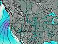
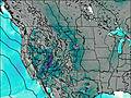
Folsom Peak Weather (Days 0-3):
The weather forecast for Folsom Peak is: Light rain (total 8mm), mostly falling on Sat afternoon. Warm (max 22°C on Fri afternoon, min 7°C on Thu night). Wind will be generally light.
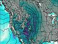
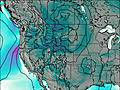
Folsom Peak Weather (Days 3-6):
Light rain (total 5mm), mostly falling on Sun night. Warm (max 25°C on Wed afternoon, min 9°C on Sun night). Winds increasing (calm on Mon night, strong winds from the SW by Wed afternoon).
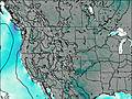
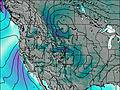
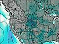
This table gives the weather forecast for Folsom Peak at the specific elevation of 2000 m. Our advanced weather models allow us to provide distinct weather forecasts for several elevations of Folsom Peak. To see the weather forecasts for the other elevations, use the tab navigation above the table. For a wider overview of the weather, consult the Weather Map of Wyoming.
| Weather Station | Temp. | Weather | Wind | Gusts | Cloud / Visibility |
|---|---|---|---|---|---|
Yellowstone Lake | |||||
West Yellowstone Airport | |||||
Livingston Airport | |||||
Ennis Big Sky Airport (Montana) | |||||
* NOTE: not all weather observatories update at the same frequency which is the reason why some locations may show data from stations that are further away than known closer ones.