– Lat/Long: 48.30° N 121.03° W
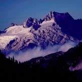
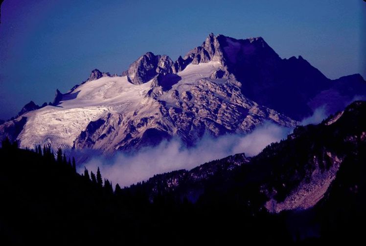
 Dome Peak
Weather Forecast, United StatesIssued: 10 pm Wed 22 Jul Local TimeUpdates in: hr min sUpdate imminent
Issued: 10 pm Wed 22 Jul Local Time
Updates in:
Update imminent hr min s

Issued: 10 pm Wed 22 Jul Local Time
Updates in:
Update imminent hr min s
Days 1–4 Weather SummaryMostly dry. Warm (max 27°C on Wed night, min 13°C on Thu night). Wind will be generally light. | Days 5–7 Weather SummaryMostly dry. Warm (max 23°C on Sun afternoon, min 10°C on Sat night). Wind will be generally light. | ||||||||||||||||||
Thursday 23 | Friday 24 | Saturday 25 | Sunday 26 | Monday 27 | Tuesday 28 | ||||||||||||||
night | AM | PM | night | AM | PM | night | AM | PM | night | AM | PM | night | AM | PM | night | AM | PM | night | |
rain shwrs | rain shwrs | clear | some clouds | clear | clear | clear | clear | clear | rain shwrs | some clouds | clear | some clouds | some clouds | clear | clear | clear | clear | clear | |
Cloud base (m) | 4400 | 1650 | 1850 | 1650 | 1800 | ||||||||||||||
km/h | |||||||||||||||||||
 |  |  |  |  |  |  | |||||||||||||
— | — | — | — | — | — | — | — | — | — | — | — | — | — | — | — | — | — | — | |
mm | 0.8 | 0.1 | — | — | — | — | — | — | — | 0.7 | — | — | — | — | — | — | — | — | — |
max °C | 27 | 22 | 26 | 19 | 22 | 25 | 21 | 20 | 22 | 15 | 16 | 23 | 19 | 15 | 20 | 17 | 17 | 22 | 19 |
min °C | 19 | 19 | 24 | 13 | 17 | 25 | 13 | 16 | 21 | 10 | 11 | 22 | 11 | 13 | 18 | 10 | 13 | 21 | 13 |
chill °C | 19 | 19 | 24 | 13 | 17 | 25 | 13 | 16 | 21 | 10 | 11 | 22 | 11 | 13 | 18 | 10 | 13 | 21 | 13 |
Freezing level m | 4450 | 4500 | 4500 | 4300 | 4250 | 4100 | 3950 | 3500 | 3500 | 3900 | 3800 | 3750 | 3450 | 3400 | 3550 | 3850 | 3800 | 3850 | 4150 |
— | 5:26 | — | — | 5:28 | — | — | 5:30 | — | — | 5:31 | — | — | 5:31 | — | — | 5:33 | — | — | |
— | — | — | 8:52 | — | — | 8:51 | — | — | 8:50 | — | — | 8:49 | — | — | 8:47 | — | — | 8:45 | |
Loading...
Dome Peak Weather (Days 0-3):
The weather forecast for Dome Peak is: Mostly dry. Warm (max 27°C on Wed night, min 13°C on Thu night). Wind will be generally light.
Dome Peak Weather (Days 3-6):
Mostly dry. Warm (max 23°C on Sun afternoon, min 10°C on Sat night). Wind will be generally light.
This table gives the weather forecast for Dome Peak at the specific elevation of 1000 m. Our advanced weather models allow us to provide distinct weather forecasts for several elevations of Dome Peak. To see the weather forecasts for the other elevations, use the tab navigation above the table. For a wider overview of the weather, consult the Weather Map of Washington.
| Weather Station | Temp. | Weather | Wind | Gusts | Cloud / Visibility |
|---|---|---|---|---|---|
Winthrop Airport (Washington) | |||||
lightning 35km NNW of Cle Elum | |||||
lightning 12km NE of Tanner | |||||
lightning 14km NE of Riverbend | |||||
lightning 4km SW of Fall City | |||||
BUOY-PBFW1 |
* NOTE: not all weather observatories update at the same frequency which is the reason why some locations may show data from stations that are further away than known closer ones.