
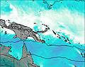
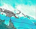
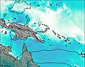
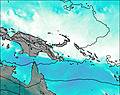
– Lat/Long: 5.90° S 143.15° E
 Doma Peaks
Weather Forecast, Papua New GuineaIssued: 9 am Sun 19 Jul Local TimeUpdates in: hr min sUpdate imminent
Issued: 9 am Sun 19 Jul Local Time
Updates in:
Update imminent hr min s

Issued: 9 am Sun 19 Jul Local Time
Updates in:
Update imminent hr min s
Days 1–3 Weather SummarySome drizzle, heaviest during Sun afternoon. Very mild (max 11°C on Mon morning, min 8°C on Sun night). Wind will be generally light. | Days 4–6 Weather SummaryMostly dry. Very mild (max 11°C on Wed morning, min 7°C on Thu afternoon). Wind will be generally light. | |||||||||||||||||
Sunday 19 | Monday 20 | Tuesday 21 | Wednesday 22 | Thursday 23 | Friday 24 | |||||||||||||
AM | PM | night | AM | PM | night | AM | PM | night | AM | PM | night | AM | PM | night | AM | PM | night | |
rain shwrs | rain shwrs | rain shwrs | rain shwrs | rain shwrs | rain shwrs | clear | rain shwrs | some clouds | clear | rain shwrs | rain shwrs | clear | rain shwrs | rain shwrs | clear | light rain | some clouds | |
Cloud base (m) | 2650 | 2500 | 2450 | 2550 | 2600 | 2400 | 2450 | 2650 | 3050 | 2450 | 3000 | 2700 | 2550 | 2650 | ||||
km/h | ||||||||||||||||||
 |  |  |  |  |  | |||||||||||||
— | — | — | — | — | — | — | — | — | — | — | — | — | — | — | — | — | — | |
mm | 0.3 | 0.6 | 0.2 | 0.1 | 0.4 | 0.1 | — | 0.1 | — | — | 0.1 | 0.1 | — | 0.1 | 0.1 | — | 0.5 | — |
max °C | 10 | 10 | 9 | 11 | 10 | 10 | 11 | 10 | 10 | 11 | 10 | 8 | 10 | 9 | 9 | 11 | 10 | 10 |
min °C | 9 | 9 | 8 | 9 | 9 | 9 | 10 | 9 | 9 | 11 | 9 | 8 | 9 | 7 | 8 | 10 | 9 | 9 |
chill °C | 9 | 9 | 8 | 9 | 9 | 9 | 10 | 9 | 9 | 11 | 9 | 8 | 9 | 7 | 8 | 10 | 8 | 8 |
Freezing level m | 4850 | 4850 | 4800 | 4850 | 4950 | 4900 | 4950 | 4950 | 4900 | 5050 | 4950 | 4700 | 4800 | 4850 | 4650 | 4950 | 4900 | 4900 |
6:39 | — | — | 6:39 | — | — | 6:39 | — | — | 6:39 | — | — | 6:39 | — | — | 6:37 | — | — | |
— | 6:28 | — | — | 6:28 | — | — | 6:28 | — | — | 6:28 | — | — | 6:28 | — | — | 6:28 | — | |
Loading...
Doma Peaks Weather (Days 0-3):
The weather forecast for Doma Peaks is: Some drizzle, heaviest during Sun afternoon. Very mild (max 11°C on Mon morning, min 8°C on Sun night). Wind will be generally light.
Doma Peaks Weather (Days 3-6):
Mostly dry. Very mild (max 11°C on Wed morning, min 7°C on Thu afternoon). Wind will be generally light.
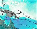
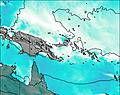
This table gives the weather forecast for Doma Peaks at the specific elevation of 3000 m. Our advanced weather models allow us to provide distinct weather forecasts for several elevations of Doma Peaks. To see the weather forecasts for the other elevations, use the tab navigation above the table. For a wider overview of the weather, consult the Weather Map of Papua New Guinea.
| Weather Station | Temp. | Weather | Wind | Gusts | Cloud / Visibility |
|---|---|---|---|---|---|
SHIP5355 | |||||
Coconut Island | |||||
Jayapur / entani Airport | |||||
Horn Island Airport | |||||
SHIP5229 | |||||
SHIP4868 | |||||
SHIP2586 | |||||
SHIP5926 |
* NOTE: not all weather observatories update at the same frequency which is the reason why some locations may show data from stations that are further away than known closer ones.