– Lat/Long: 42.47° N 13.57° E
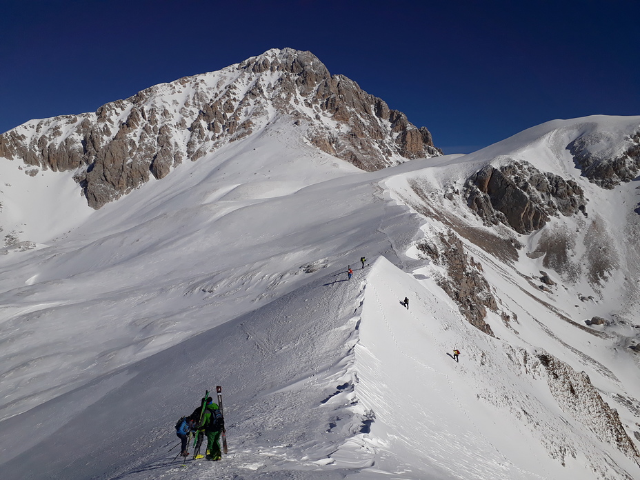
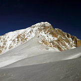
 Corno Grande
Weather Forecast, ItalyIssued: 1 pm Mon 03 Aug Local TimeUpdates in: hr min sUpdate imminent
Issued: 1 pm Mon 03 Aug Local Time
Updates in:
Update imminent hr min s

Issued: 1 pm Mon 03 Aug Local Time
Updates in:
Update imminent hr min s
Days 1–4 Weather SummaryModerate rain (total 13mm), heaviest on Wed afternoon. Very mild (max 12°C on Tue afternoon, min 8°C on Wed afternoon). Wind will be generally light. | Days 5–7 Weather SummaryLight rain (total 3mm), mostly falling on Fri afternoon. Very mild (max 12°C on Thu afternoon, min 10°C on Sat night). Wind will be generally light. | ||||||||||||||||
Mon 3 | Tuesday 4 | Wednesday 5 | Thursday 6 | Friday 7 | Saturday 8 | ||||||||||||
PM | night | AM | PM | night | AM | PM | night | AM | PM | night | AM | PM | night | AM | PM | night | |
light rain | rain shwrs | clear | some clouds | clear | clear | risk tstorm | rain shwrs | clear | some clouds | clear | clear | rain shwrs | rain shwrs | clear | rain shwrs | risk tstorm | |
Cloud base (m) | 3000 | 9550 | 3400 | 2300 | 4350 | 3100 | |||||||||||
km/h | |||||||||||||||||
 |  |  |  |  |  | ||||||||||||
— | — | — | — | — | — | — | — | — | — | — | — | — | — | — | — | — | |
mm | 0.1 | 0.2 | — | — | — | — | 12 | 1.1 | — | — | — | — | 1.3 | 0.5 | — | 0.9 | 0.2 |
max °C | 11 | 11 | 10 | 12 | 11 | 11 | 11 | 11 | 11 | 12 | 12 | 11 | 12 | 11 | 11 | 12 | 11 |
min °C | 9 | 10 | 10 | 11 | 11 | 10 | 8 | 10 | 10 | 12 | 11 | 11 | 11 | 11 | 11 | 12 | 10 |
chill °C | 8 | 9 | 10 | 10 | 9 | 9 | 8 | 8 | 8 | 12 | 11 | 10 | 9 | 9 | 9 | 11 | 10 |
Freezing level m | 4350 | 4450 | 4400 | 4500 | 4500 | 4400 | 4250 | 4450 | 4400 | 4600 | 4550 | 4500 | 4500 | 4600 | 4500 | 4600 | 4550 |
— | — | 6:00 | — | — | 6:01 | — | — | 6:01 | — | — | 6:03 | — | — | 6:03 | — | — | |
— | 8:22 | — | — | 8:22 | — | — | 8:21 | — | — | 8:20 | — | — | 8:17 | — | — | 8:16 | |
Loading...
Corno Grande Weather (Days 0-3):
The weather forecast for Corno Grande is: Moderate rain (total 13mm), heaviest on Wed afternoon. Very mild (max 12°C on Tue afternoon, min 8°C on Wed afternoon). Wind will be generally light.
Corno Grande Weather (Days 3-6):
Light rain (total 3mm), mostly falling on Fri afternoon. Very mild (max 12°C on Thu afternoon, min 10°C on Sat night). Wind will be generally light.
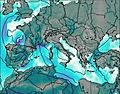
This table gives the weather forecast for Corno Grande at the specific elevation of 2912 m. Our advanced weather models allow us to provide distinct weather forecasts for several elevations of Corno Grande. To see the weather forecasts for the other elevations, use the tab navigation above the table. For a wider overview of the weather, consult the Weather Map of Italy.
| Weather Station | Temp. | Weather | Wind | Gusts | Cloud / Visibility |
|---|---|---|---|---|---|
lightning 10km NW of Pizzoli | |||||
lightning 11km E of Antrodoco | |||||
lightning 8km N of Magliano de' Marsi | |||||
lightning 7km NNE of Leonessa | |||||
lightning 5km SE of Cascia | |||||
lightning 5km SW of Norcia | |||||
thunderstorm affecting Gioia dei Marsi | |||||
lightning 6km ESE of Lecce ne' Marsi |
* NOTE: not all weather observatories update at the same frequency which is the reason why some locations may show data from stations that are further away than known closer ones.
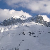
Corno Grande Photos
View all
Apennines photos (133) |
Italian Peninsula and Islands photos (160) |
photos from mountains in Italy (430) |
all photos
 Upload new photo
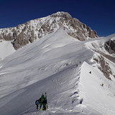
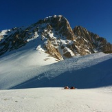
Vetta Occidentale
Corno Grande
Corno Piccolo from Prati di Tivo