– Lat/Long: 48.96° N 114.02° W
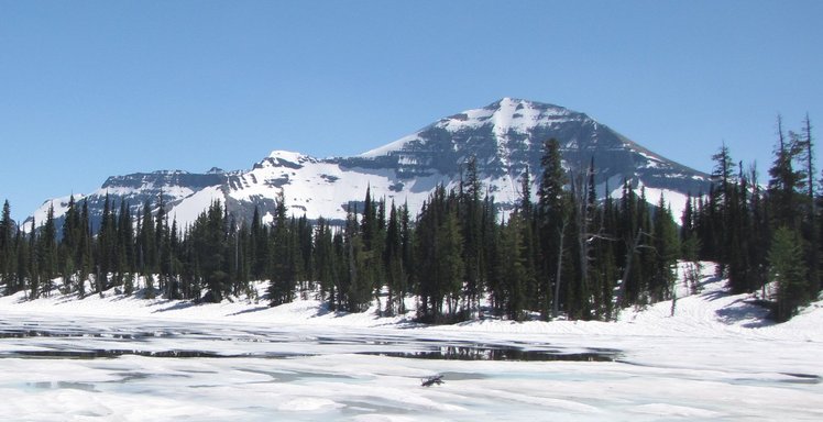
 Chapman Peak
Weather Forecast, CanadaIssued: 11 pm Sun 02 Aug Local TimeUpdates in: hr min sUpdate imminent
Issued: 11 pm Sun 02 Aug Local Time
Updates in:
Update imminent hr min s

Issued: 11 pm Sun 02 Aug Local Time
Updates in:
Update imminent hr min s
Days 1–4 Weather SummaryMostly dry. Freeze-thaw conditions (max 12°C on Wed afternoon, min -2°C on Sun night). Mainly fresh winds. | Days 5–7 Weather SummaryMostly dry. Very mild (max 15°C on Thu afternoon, min 7°C on Sat morning). Winds decreasing (strong winds from the WSW on Fri afternoon, light winds from the SSW by Sat afternoon). | ||||||||||||||||||
Monday 3 | Tuesday 4 | Wednesday 5 | Thursday 6 | Friday 7 | Saturday 8 | ||||||||||||||
night | AM | PM | night | AM | PM | night | AM | PM | night | AM | PM | night | AM | PM | night | AM | PM | night | |
some clouds | cloudy | some clouds | some clouds | clear | some clouds | clear | clear | clear | clear | clear | clear | clear | clear | clear | clear | clear | some clouds | clear | |
Cloud base (m) | 1950 | 2850 | 3350 | 4200 | 4400 | 8900 | 4650 | 9250 | |||||||||||
km/h | |||||||||||||||||||
 |  |  |  |  |  |  | |||||||||||||
— | — | — | — | — | — | — | — | — | — | — | — | — | — | — | — | — | — | — | |
mm | — | — | — | — | — | — | — | — | — | — | — | — | — | — | — | — | — | — | — |
max °C | 2 | -1 | 3 | 3 | 5 | 8 | 8 | 8 | 12 | 11 | 11 | 15 | 14 | 13 | 14 | 12 | 8 | 10 | 9 |
min °C | -2 | -2 | 1 | 2 | 4 | 7 | 7 | 7 | 11 | 10 | 10 | 14 | 11 | 12 | 14 | 9 | 7 | 10 | 6 |
chill °C | -2 | -2 | -1 | 0 | 3 | 4 | 4 | 4 | 8 | 8 | 8 | 12 | 9 | 9 | 11 | 5 | 5 | 8 | 5 |
Freezing level m | 2900 | 2500 | 2900 | 3300 | 3350 | 3750 | 4000 | 4000 | 4400 | 4550 | 4450 | 4600 | 4800 | 4650 | 4750 | 4550 | 4150 | 4250 | 4000 |
— | 6:11 | — | — | 6:11 | — | — | 6:13 | — | — | 6:15 | — | — | 6:16 | — | — | 6:18 | — | — | |
— | — | — | 9:12 | — | — | 9:09 | — | — | 9:08 | — | — | 9:07 | — | — | 9:06 | — | — | 9:04 | |
Loading...
Chapman Peak Weather (Days 0-3):
The weather forecast for Chapman Peak is: Mostly dry. Freeze-thaw conditions (max 12°C on Wed afternoon, min -2°C on Sun night). Mainly fresh winds.
Chapman Peak Weather (Days 3-6):
Mostly dry. Very mild (max 15°C on Thu afternoon, min 7°C on Sat morning). Winds decreasing (strong winds from the WSW on Fri afternoon, light winds from the SSW by Sat afternoon).
This table gives the weather forecast for Chapman Peak at the specific elevation of 2867 m. Our advanced weather models allow us to provide distinct weather forecasts for several elevations of Chapman Peak. To see the weather forecasts for the other elevations, use the tab navigation above the table. For a wider overview of the weather, consult the Weather Map of Alberta.
| Weather Station | Temp. | Weather | Wind | Gusts | Cloud / Visibility |
|---|---|---|---|---|---|
Waterton Park Gate- Alta | |||||
Bullhorn Headwaters- Alta | |||||
Carway- Alta | |||||
Glenwood- Alta | |||||
Cardston- Alta | |||||
Pincher Creek Airport |
* NOTE: not all weather observatories update at the same frequency which is the reason why some locations may show data from stations that are further away than known closer ones.
Chapman Peak Photos
View all
Canadian Rockies photos (92) |
photos from mountains in Canada (457) |
all photos
 Upload new photo
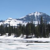
Chapman Peak