
– Lat/Long: 29.12° S 69.80° W
 Cerro El Toro
Weather Forecast, ArgentinaIssued: 1 pm Tue 28 Jul Local TimeUpdates in: hr min sUpdate imminent
Issued: 1 pm Tue 28 Jul Local Time
Updates in:
Update imminent hr min s

Issued: 1 pm Tue 28 Jul Local Time
Updates in:
Update imminent hr min s
Days 1–4 Weather SummaryA dusting of new snow. Freeze-thaw conditions (max 2°C on Thu afternoon, min -10°C on Tue night). Winds increasing (light winds from the WNW on Tue night, fresh winds from the WNW by Thu night). | Days 5–7 Weather SummaryA light covering of new snow mostly falling on Fri night. Freeze-thaw conditions (max 2°C on Sun afternoon, min -13°C on Fri night). Winds decreasing (fresh winds from the WNW on Fri afternoon, light winds from the WNW by Sun morning). | ||||||||||||||||
Tue 28 | Wednesday 29 | Thursday 30 | Friday 31 | Saturday 1 | Sunday 2 | ||||||||||||
PM | night | AM | PM | night | AM | PM | night | AM | PM | night | AM | PM | night | AM | PM | night | |
some clouds | some clouds | snow shwrs | some clouds | some clouds | clear | clear | clear | cloudy | light snow | snow shwrs | cloudy | some clouds | some clouds | some clouds | clear | clear | |
Cloud base (m) | 6200 | 5100 | 4700 | 5850 | 5200 | 4650 | 6300 | 6100 | 5800 | ||||||||
km/h | |||||||||||||||||
 |  |  |  |  |  | ||||||||||||
— | — | 1 | — | — | — | — | — | — | 2 | 5 | — | — | — | — | — | — | |
mm | — | — | — | — | — | — | — | — | — | — | — | — | — | — | — | — | — |
max °C | -3 | -3 | 0 | 0 | -3 | 1 | 2 | -6 | -7 | -6 | -7 | -1 | 0 | -2 | 1 | 2 | -4 |
min °C | -5 | -10 | -3 | -1 | -5 | -5 | -2 | -9 | -8 | -7 | -13 | -7 | -2 | -5 | -4 | -1 | -6 |
chill °C | -12 | -15 | -8 | -6 | -11 | -11 | -8 | -18 | -17 | -16 | -20 | -13 | -7 | -11 | -8 | -6 | -12 |
Freezing level m | 2650 | 2900 | 3550 | 3350 | 2800 | 3600 | 3200 | 2000 | 2500 | 2500 | 1700 | 3350 | 3250 | 2950 | 3650 | 3400 | 2850 |
— | — | 7:24 | — | — | 7:24 | — | — | 7:24 | — | — | 7:22 | — | — | 7:22 | — | — | |
6:05 | — | — | 6:06 | — | — | 6:06 | — | — | 6:07 | — | — | 6:07 | — | — | 6:07 | — | |
Loading...
Cerro El Toro Weather (Days 0-3):
The weather forecast for Cerro El Toro is: A dusting of new snow. Freeze-thaw conditions (max 2°C on Thu afternoon, min -10°C on Tue night). Winds increasing (light winds from the WNW on Tue night, fresh winds from the WNW by Thu night).
Cerro El Toro Weather (Days 3-6):
A light covering of new snow mostly falling on Fri night. Freeze-thaw conditions (max 2°C on Sun afternoon, min -13°C on Fri night). Winds decreasing (fresh winds from the WNW on Fri afternoon, light winds from the WNW by Sun morning).
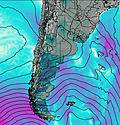
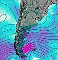
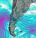
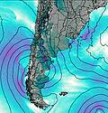
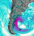
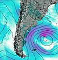
This table gives the weather forecast for Cerro El Toro at the specific elevation of 3500 m. Our advanced weather models allow us to provide distinct weather forecasts for several elevations of Cerro El Toro. To see the weather forecasts for the other elevations, use the tab navigation above the table. For a wider overview of the weather, consult the Weather Map of Argentina.
| Weather Station | Temp. | Weather | Wind | Gusts | Cloud / Visibility |
|---|---|---|---|---|---|
Vicuña- Parque Los Pimientos | |||||
Copiapó Universidad de Atacama | |||||
Monte Patria- Municipalidad | |||||
Ovalle Escuela Agrícola | |||||
Desierto Atacama Airport | |||||
* NOTE: not all weather observatories update at the same frequency which is the reason why some locations may show data from stations that are further away than known closer ones.