
– Lat/Long: 50.06° N 114.66° W
 Beehive Mountain
Weather Forecast, CanadaIssued: 5 am Sat 06 Jun Local TimeUpdates in: hr min sUpdate imminent
Issued: 5 am Sat 06 Jun Local Time
Updates in:
Update imminent hr min s

Issued: 5 am Sat 06 Jun Local Time
Updates in:
Update imminent hr min s
Days 1–3 Weather SummaryA dusting of new snow. Temperatures will be below freezing (max 0°C on Sat afternoon, min -7°C on Sat night). Winds decreasing (near gales from the WSW on Sat night, calm by Mon night). | Days 4–6 Weather SummaryA heavy fall of snow, heaviest during Wed afternoon. Temperatures will be below freezing (max -1°C on Thu afternoon, min -3°C on Tue morning). Wind will be generally light. | |||||||||||||||||
Saturday 6 | Sunday 7 | Monday 8 | Tuesday 9 | Wednesday 10 | Thursday 11 | |||||||||||||
AM | PM | night | AM | PM | night | AM | PM | night | AM | PM | night | AM | PM | night | AM | PM | night | |
some clouds | some clouds | clear | some clouds | light snow | some clouds | clear | some clouds | some clouds | cloudy | light snow | mod. snow | mod. snow | mod. snow | cloudy | cloudy | cloudy | some clouds | |
km/h | ||||||||||||||||||
 |  |  |  |  |  | |||||||||||||
— | — | — | — | 1 | — | — | — | — | — | 1 | 10 | 10 | 7 | — | — | — | — | |
— | — | — | — | — | — | — | — | — | — | — | — | — | — | — | — | — | — | |
max °C | -1 | 0 | -5 | -4 | -4 | -3 | -2 | 0 | 0 | -2 | -2 | -3 | -3 | -2 | -2 | -2 | -1 | -1 |
min °C | -3 | -3 | -7 | -7 | -4 | -4 | -3 | 0 | -3 | -3 | -2 | -3 | -3 | -3 | -2 | -2 | -1 | -2 |
-10 | -13 | -17 | -14 | -10 | -13 | -12 | -7 | -3 | -3 | -8 | -10 | -10 | -9 | -8 | -5 | -5 | -5 | |
2500 | 2850 | 1900 | 2100 | 2500 | 2150 | 2450 | 2850 | 2750 | 2550 | 2550 | 2400 | 2250 | 2350 | 2500 | 2500 | 2750 | 2500 | |
Cloud base (m) | 2300 | 2750 | 2100 | 1900 | 3250 | 2100 | 1900 | 1900 | 1900 | 1900 | 1900 | 2000 | 2000 | 2450 | ||||
5:31 | — | — | 5:30 | — | — | 5:30 | — | — | 5:30 | — | — | 5:28 | — | — | 5:28 | — | — | |
— | — | 9:43 | — | — | 9:44 | — | — | 9:45 | — | — | 9:45 | — | — | 9:45 | — | — | 9:46 | |
Loading...
Beehive Mountain Weather (Days 0-3):
The weather forecast for Beehive Mountain is: A dusting of new snow. Temperatures will be below freezing (max 0°C on Sat afternoon, min -7°C on Sat night). Winds decreasing (near gales from the WSW on Sat night, calm by Mon night).
Beehive Mountain Weather (Days 3-6):
A heavy fall of snow, heaviest during Wed afternoon. Temperatures will be below freezing (max -1°C on Thu afternoon, min -3°C on Tue morning). Wind will be generally light.
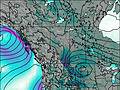
This table gives the weather forecast for Beehive Mountain at the specific elevation of 2895 m. Our advanced weather models allow us to provide distinct weather forecasts for several elevations of Beehive Mountain. To see the weather forecasts for the other elevations, use the tab navigation above the table. For a wider overview of the weather, consult the Weather Map of Alberta.
| Weather Station | Temp. | Weather | Wind | Gusts | Cloud / Visibility |
|---|---|---|---|---|---|
Sparwoo / lk Valley Airport | |||||
Sparwood Cs- BC | |||||
Sparwood Airport | |||||
Crowsnest-Alta | |||||
Stavely Aafc- Alta | |||||
Azure- Alta | |||||
Morrissey Ridge | |||||
Claresholm-Alta | |||||
* NOTE: not all weather observatories update at the same frequency which is the reason why some locations may show data from stations that are further away than known closer ones.