
– Lat/Long: 38.54° N 22.58° E
 Καταφύγιο Σαραντάρι (Sarandari Refuge)
Weather Forecast, GreeceIssued: 8 pm Wed 24 Jun Local TimeUpdates in: hr min sUpdate imminent
Issued: 8 pm Wed 24 Jun Local Time
Updates in:
Update imminent hr min s

Issued: 8 pm Wed 24 Jun Local Time
Updates in:
Update imminent hr min s
Days 1–4 Weather SummaryLight rain (total 4mm), mostly falling on Wed night. Very mild (max 16°C on Fri afternoon, min 13°C on Wed night). Winds increasing (calm on Wed night, fresh winds from the NE by Sat afternoon). | Days 5–7 Weather SummaryMostly dry. Very mild (max 17°C on Tue afternoon, min 12°C on Sat night). Winds decreasing (strong winds from the NE on Sat night, light winds from the NE by Tue afternoon). | ||||||||||||||||||
Thursday 25 | Friday 26 | Saturday 27 | Sunday 28 | Monday 29 | Tuesday 30 | ||||||||||||||
night | AM | PM | night | AM | PM | night | AM | PM | night | AM | PM | night | AM | PM | night | AM | PM | night | |
rain shwrs | clear | rain shwrs | rain shwrs | some clouds | some clouds | rain shwrs | clear | clear | clear | clear | clear | clear | clear | clear | rain shwrs | clear | risk tstorm | rain shwrs | |
km/h | |||||||||||||||||||
 |  |  |  |  |  |  | |||||||||||||
— | — | — | — | — | — | — | — | — | — | — | — | — | — | — | — | — | — | — | |
mm | 4 | — | 0.1 | 0.1 | — | — | 0.1 | — | — | — | — | — | — | — | — | 0.7 | — | 0.1 | 0.2 |
max °C | 15 | 14 | 15 | 15 | 15 | 16 | 15 | 14 | 15 | 15 | 13 | 14 | 14 | 14 | 15 | 15 | 15 | 17 | 17 |
min °C | 13 | 13 | 15 | 14 | 14 | 15 | 13 | 13 | 14 | 12 | 12 | 14 | 13 | 13 | 15 | 14 | 14 | 16 | 15 |
chill °C | 12 | 12 | 15 | 12 | 12 | 13 | 10 | 10 | 12 | 9 | 9 | 12 | 11 | 11 | 14 | 12 | 13 | 16 | 14 |
Freezing level m | 4100 | 4000 | 3950 | 4100 | 3900 | 3800 | 4000 | 4150 | 4300 | 4250 | 4300 | 4300 | 4200 | 4100 | 4050 | 4000 | 4000 | 3950 | 4050 |
Cloud base (m) | 4500 | 2650 | 2550 | 6850 | |||||||||||||||
— | 6:05 | — | — | 6:07 | — | — | 6:07 | — | — | 6:07 | — | — | 6:07 | — | — | 6:07 | — | — | |
— | — | 8:57 | — | — | 8:58 | — | — | 8:58 | — | — | 8:58 | — | — | 8:58 | — | — | 8:57 | — | |
Loading...
Καταφύγιο Σαραντάρι Weather (Days 0-3):
The weather forecast for Καταφύγιο Σαραντάρι is: Light rain (total 4mm), mostly falling on Wed night. Very mild (max 16°C on Fri afternoon, min 13°C on Wed night). Winds increasing (calm on Wed night, fresh winds from the NE by Sat afternoon).
Καταφύγιο Σαραντάρι Weather (Days 3-6):
Mostly dry. Very mild (max 17°C on Tue afternoon, min 12°C on Sat night). Winds decreasing (strong winds from the NE on Sat night, light winds from the NE by Tue afternoon).
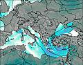
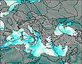
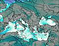
This table gives the weather forecast for Καταφύγιο Σαραντάρι at the specific elevation of 1782 m. Our advanced weather models allow us to provide distinct weather forecasts for several elevations of Καταφύγιο Σαραντάρι. To see the weather forecasts for the other elevations, use the tab navigation above the table. For a wider overview of the weather, consult the Weather Map of Greece.
| Weather Station | Temp. | Weather | Wind | Gusts | Cloud / Visibility |
|---|---|---|---|---|---|
AOK-Kitheronas | |||||
Aghialos Airport | |||||
Skiathos Island Airport | |||||
Araxos Airport | |||||
SHIP1211 | |||||
SHIP2391 | |||||
SHIP1960 | |||||
SHIP6402 |
* NOTE: not all weather observatories update at the same frequency which is the reason why some locations may show data from stations that are further away than known closer ones.