
– Lat/Long: 39.93° N 21.10° E
 Πυροφυλάκειο στο Αυγό (Fire Watch Tower On Avgo)
Weather Forecast, GreeceIssued: 2 pm Tue 30 Jun Local TimeUpdates in: hr min sUpdate imminent
Issued: 2 pm Tue 30 Jun Local Time
Updates in:
Update imminent hr min s

Issued: 2 pm Tue 30 Jun Local Time
Updates in:
Update imminent hr min s
Days 1–4 Weather SummaryLight rain (total 10mm), mostly falling on Wed afternoon. Very mild (max 15°C on Tue afternoon, min 13°C on Tue night). Wind will be generally light. | Days 5–7 Weather SummaryLight rain (total 4mm), mostly falling on Fri afternoon. Very mild (max 15°C on Fri afternoon, min 11°C on Sat night). Wind will be generally light. | ||||||||||||||||
Tue 30 | Wednesday 1 | Thursday 2 | Friday 3 | Saturday 4 | Sunday 5 | ||||||||||||
PM | night | AM | PM | night | AM | PM | night | AM | PM | night | AM | PM | night | AM | PM | night | |
risk tstorm | rain shwrs | clear | rain shwrs | rain shwrs | clear | risk tstorm | rain shwrs | rain shwrs | risk tstorm | risk tstorm | clear | some clouds | clear | clear | some clouds | clear | |
km/h | |||||||||||||||||
 |  |  |  |  |  | ||||||||||||
— | — | — | — | — | — | — | — | — | — | — | — | — | — | — | — | — | |
mm | 2 | 1.3 | — | 3 | 0.3 | — | 0.3 | 1.8 | 0.2 | 3 | 1.2 | — | — | — | — | — | — |
max °C | 15 | 14 | 15 | 15 | 14 | 15 | 15 | 14 | 14 | 15 | 15 | 14 | 15 | 14 | 12 | 14 | 14 |
min °C | 14 | 13 | 13 | 13 | 13 | 13 | 15 | 13 | 13 | 15 | 13 | 12 | 14 | 11 | 11 | 14 | 13 |
chill °C | 12 | 12 | 13 | 13 | 12 | 13 | 15 | 13 | 13 | 15 | 12 | 11 | 14 | 10 | 10 | 14 | 12 |
Freezing level m | 4000 | 3950 | 3900 | 3900 | 4050 | 4150 | 4150 | 4300 | 4250 | 4250 | 4200 | 4100 | 3950 | 4000 | 3850 | 3900 | 3850 |
Cloud base (m) | 3400 | 4400 | 3450 | 3100 | 5150 | 3350 | 2400 | 3500 | 3200 | 3500 | |||||||
— | — | 6:09 | — | — | 6:11 | — | — | 6:11 | — | — | 6:11 | — | — | 6:11 | — | — | |
— | 9:07 | — | — | 9:07 | — | — | 9:07 | — | — | 9:07 | — | — | 9:07 | — | — | 9:07 | |
Loading...
Πυροφυλάκειο στο Αυγό Weather (Days 0-3):
The weather forecast for Πυροφυλάκειο στο Αυγό is: Light rain (total 10mm), mostly falling on Wed afternoon. Very mild (max 15°C on Tue afternoon, min 13°C on Tue night). Wind will be generally light.
Πυροφυλάκειο στο Αυγό Weather (Days 3-6):
Light rain (total 4mm), mostly falling on Fri afternoon. Very mild (max 15°C on Fri afternoon, min 11°C on Sat night). Wind will be generally light.
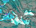
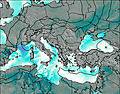
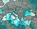
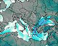
This table gives the weather forecast for Πυροφυλάκειο στο Αυγό at the specific elevation of 2111 m. Our advanced weather models allow us to provide distinct weather forecasts for several elevations of Πυροφυλάκειο στο Αυγό. To see the weather forecasts for the other elevations, use the tab navigation above the table. For a wider overview of the weather, consult the Weather Map of Greece.
| Weather Station | Temp. | Weather | Wind | Gusts | Cloud / Visibility |
|---|---|---|---|---|---|
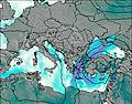
lightning 23km NNW of Metsovon | |||||
Ioannina (Airport) | |||||
lightning 8km WNW of Kastrakion | |||||
lightning 5km S of Koutselion | |||||
lightning 17km SSW of Leskovik | |||||
lightning 21km WSW of Konitsa | |||||
lightning 9km WSW of Pramanta | |||||
lightning 11km SW of Kalampaka | |||||
lightning 26km WNW of Rodotopion | |||||
lightning 13km WNW of Pyli |
* NOTE: not all weather observatories update at the same frequency which is the reason why some locations may show data from stations that are further away than known closer ones.