– Lat/Long: 57.19° N 5.35° W
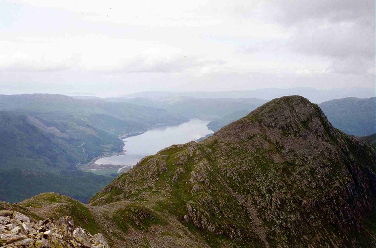
 Sgùrr na Càrnach
Weather Forecast, United KingdomIssued: 12 pm Fri 26 Apr Local TimeUpdates in: hr min sUpdate imminent
Sgùrr na CàrnachWeather Forecast, United Kingdom
Issued: 12 pm Fri 26 Apr Local Time
Updates in:
Update imminent hr min s

Issued: 12 pm Fri 26 Apr Local Time
Updates in:
Update imminent hr min s
Days 1–3 Weather SummaryA light covering of new snow mostly falling on Fri afternoon. Freeze-thaw conditions (max 1°C on Sun morning, min -2°C on Fri morning). Winds increasing (calm on Sun morning, fresh winds from the SSW by Sun night). | Days 4–6 Weather SummaryLight rain (total 4mm), mostly falling on Mon afternoon. Mild temperatures (max 8°C on Wed morning, min 1°C on Mon morning). Winds decreasing (near gales from the SE on Tue night, light winds from the ESE by Wed afternoon). | Days 7–9 Weather SummaryDrizzle on Fri afternoon turning to light snow on Sat night. Freeze-thaw conditions (max 11°C on Fri afternoon, min -1°C on Sat night). Winds increasing (calm on Fri afternoon, fresh winds from the E by Sat night). | Days 10–12 Weather SummaryA moderate fall of snow, heaviest on Mon afternoon. Freeze-thaw conditions (max 1°C on Sun afternoon, min -3°C on Sun night). Winds decreasing (strong winds from the WSW on Mon morning, calm by Wed morning). | |||||||||||||||||||||||||||||||||
Friday 26 | Saturday 27 | Sunday 28 | Monday 29 | Tuesday 30 | Wednesday 1 | Thursday 2 | Friday 3 | Saturday 4 | Sunday 5 | Monday 6 | Tuesday 7 | |||||||||||||||||||||||||
AM | PM | night | AM | PM | night | AM | PM | night | AM | PM | night | AM | PM | night | AM | PM | night | AM | PM | night | AM | PM | night | AM | PM | night | AM | PM | night | AM | PM | night | AM | PM | night | |
cloudy | light snow | light snow | light snow | light snow | clear | some clouds | some clouds | some clouds | cloudy | light rain | light rain | cloudy | light rain | rain shwrs | clear | clear | rain shwrs | cloudy | some clouds | some clouds | clear | light rain | rain shwrs | light rain | light rain | mod. snow | light snow | light snow | cloudy | light snow | light snow | light snow | light snow | snow shwrs | snow shwrs | |
km/h | ||||||||||||||||||||||||||||||||||||
Wave Height Map |  |  |  |  |  |  |  |  |  |  |  |  | ||||||||||||||||||||||||
— | 2.0 | 1.0 | 1.0 | 1.0 | — | — | — | — | — | — | — | — | — | — | — | — | — | — | — | — | — | — | — | — | — | 7 | 2.0 | 1.0 | — | 4 | 4 | 1.0 | 1.0 | 2.0 | 2.0 | |
— | — | — | — | — | — | — | — | — | — | 2 | 0.1 | — | 0.6 | 0.3 | — | — | 0.1 | — | — | — | — | 0.5 | 0.4 | 0.1 | 0.3 | — | — | — | — | — | — | — | — | — | — | |
max°C | -1 | 0 | -1 | 0 | 0 | 0 | 1 | 1 | 0 | 2 | 2 | 2 | 5 | 6 | 5 | 8 | 8 | 7 | 9 | 9 | 8 | 10 | 11 | 9 | 6 | 4 | 1 | 0 | 1 | 0 | -2 | -2 | -3 | -2 | -1 | -2 |
min°C | -2 | 0 | -2 | -1 | 0 | -1 | 0 | 1 | 0 | 1 | 2 | 2 | 3 | 6 | 5 | 6 | 8 | 7 | 8 | 9 | 8 | 9 | 10 | 7 | 5 | 3 | -1 | 0 | 0 | -3 | -2 | -2 | -3 | -2 | -2 | -2 |
-6 | 0 | -5 | -3 | -3 | -5 | -2 | -1 | -5 | -6 | -4 | -5 | -3 | 0 | -1 | 2 | 5 | 3 | 4 | 6 | 4 | 7 | 10 | 6 | 2 | -2 | -7 | -5 | -5 | -8 | -6 | -10 | -9 | -8 | -9 | -8 | |
800 | 1000 | 800 | 850 | 1050 | 850 | 1000 | 1150 | 1000 | 1200 | 1300 | 1350 | 1350 | 1850 | 2050 | 2150 | 2200 | 2450 | 2750 | 2750 | 2800 | 2700 | 2600 | 2350 | 2100 | 1850 | 1050 | 950 | 1150 | 900 | 600 | 700 | 600 | 700 | 850 | 700 | |
Cloud base (m) | 350 | 650 | 350 | 600 | 400 | 700 | 650 | 800 | 800 | 350 | 350 | 400 | 750 | 1600 | 500 | 450 | 600 | 500 | 400 | 350 | 350 | 400 | 1550 | 850 | 600 | 350 | 300 | 300 | 300 | 350 | 300 | 300 | 300 | 350 | 650 | 450 |
5:43 | — | — | 5:41 | — | — | 5:37 | — | — | 5:35 | — | — | 5:33 | — | — | 5:31 | — | — | 5:28 | — | — | 5:26 | — | — | 5:24 | — | — | 5:22 | — | — | 5:20 | — | — | 5:16 | — | — | |
— | 8:55 | — | — | 8:58 | — | — | 9:00 | — | — | 9:01 | — | — | 9:04 | — | — | 9:06 | — | — | 9:07 | — | — | 9:09 | — | — | 9:13 | — | — | 9:15 | — | — | 9:16 | — | — | 9:19 | — | |
Sgùrr na Càrnach Weather (Days 0-3):
The weather forecast for Sgùrr na Càrnach is: A light covering of new snow mostly falling on Fri afternoon. Freeze-thaw conditions (max 1°C on Sun morning, min -2°C on Fri morning). Winds increasing (calm on Sun morning, fresh winds from the SSW by Sun night).
Sgùrr na Càrnach Weather (Days 3-6):
Light rain (total 4mm), mostly falling on Mon afternoon. Mild temperatures (max 8°C on Wed morning, min 1°C on Mon morning). Winds decreasing (near gales from the SE on Tue night, light winds from the ESE by Wed afternoon).
Sgùrr na Càrnach Weather (Days 6-9):
Drizzle on Fri afternoon turning to light snow on Sat night. Freeze-thaw conditions (max 11°C on Fri afternoon, min -1°C on Sat night). Winds increasing (calm on Fri afternoon, fresh winds from the E by Sat night).
This table gives the weather forecast for Sgùrr na Càrnach at the specific elevation of 1002 m. Our advanced weather models allow us to provide distinct weather forecasts for several elevations of Sgùrr na Càrnach. To see the weather forecasts for the other elevations, use the tab navigation above the table. For a wider overview of the weather, consult the Weather Map of United Kingdom.
Sgùrr na Càrnach Photos
View all
Northwest Highlands photos (29) |
Scottish Highlands photos (262) |
photos from mountains in United Kingdom (1743) |
all photos
 Upload new photo
Sgùrr na Càrnach
 Like us
 Follow us
