– Lat/Long: 44.14° N 73.99° W
 Algonquin Peak
Weather Forecast, United StatesIssued: 7 pm Tue 30 Jun Local TimeUpdates in: hr min sUpdate imminent
Issued: 7 pm Tue 30 Jun Local Time
Updates in:
Update imminent hr min s

Issued: 7 pm Tue 30 Jun Local Time
Updates in:
Update imminent hr min s
Days 1–4 Weather SummaryLight rain (total 4mm), mostly falling on Wed afternoon. Warm (max 21°C on Wed afternoon, min 17°C on Tue night). Winds increasing (fresh winds from the W on Wed afternoon, gales from the WNW by Thu night). | Days 5–7 Weather SummaryModerate rain (total 16mm), heaviest on Sun afternoon. Warm (max 20°C on Sat afternoon, min 14°C on Sun morning). Winds decreasing (near gales from the W on Sat night, light winds from the NW by Sun morning). | ||||||||||||||||||
Wednesday 1 | Thursday 2 | Friday 3 | Saturday 4 | Sunday 5 | Monday 6 | ||||||||||||||
night | AM | PM | night | AM | PM | night | AM | PM | night | AM | PM | night | AM | PM | night | AM | PM | night | |
risk tstorm | risk tstorm | risk tstorm | risk tstorm | some clouds | clear | rain shwrs | clear | clear | clear | clear | rain shwrs | risk tstorm | risk tstorm | mod. rain | rain shwrs | clear | some clouds | clear | |
km/h | |||||||||||||||||||
 |  |  |  |  |  |  | |||||||||||||
— | — | — | — | — | — | — | — | — | — | — | — | — | — | — | — | — | — | — | |
mm | 1.2 | 0.7 | 1.2 | 0.2 | — | — | 0.2 | — | — | — | — | 1.4 | 4 | 1.6 | 9 | 0.5 | — | — | — |
max °C | 19 | 19 | 21 | 21 | 19 | 21 | 20 | 18 | 19 | 19 | 17 | 20 | 17 | 14 | 14 | 14 | 15 | 17 | 16 |
min °C | 17 | 19 | 19 | 19 | 19 | 20 | 18 | 17 | 18 | 17 | 17 | 17 | 15 | 14 | 14 | 14 | 14 | 17 | 15 |
chill °C | 15 | 18 | 18 | 18 | 18 | 19 | 16 | 15 | 16 | 16 | 15 | 15 | 14 | 13 | 13 | 13 | 12 | 17 | 14 |
Freezing level m | 5000 | 4950 | 5000 | 5000 | 4900 | 4900 | 4850 | 4850 | 4600 | 4450 | 4600 | 4550 | 4450 | 4250 | 4100 | 4150 | 3950 | 3750 | 4050 |
Cloud base (m) | 800 | 550 | 8850 | 600 | 8250 | 9150 | 6100 | 6150 | 2200 | 450 | 550 | 800 | 2800 | ||||||
— | 5:16 | — | — | 5:16 | — | — | 5:16 | — | — | 5:16 | — | — | 5:18 | — | — | 5:18 | — | — | |
— | — | — | 8:43 | — | — | 8:42 | — | — | 8:42 | — | — | 8:42 | — | — | 8:42 | — | — | 8:40 | |
Loading...
Algonquin Peak Weather (Days 0-3):
The weather forecast for Algonquin Peak is: Light rain (total 4mm), mostly falling on Wed afternoon. Warm (max 21°C on Wed afternoon, min 17°C on Tue night). Winds increasing (fresh winds from the W on Wed afternoon, gales from the WNW by Thu night).
Algonquin Peak Weather (Days 3-6):
Moderate rain (total 16mm), heaviest on Sun afternoon. Warm (max 20°C on Sat afternoon, min 14°C on Sun morning). Winds decreasing (near gales from the W on Sat night, light winds from the NW by Sun morning).
This table gives the weather forecast for Algonquin Peak at the specific elevation of 1559 m. Our advanced weather models allow us to provide distinct weather forecasts for several elevations of Algonquin Peak. To see the weather forecasts for the other elevations, use the tab navigation above the table. For a wider overview of the weather, consult the Weather Map of New-York.
| Weather Station | Temp. | Weather | Wind | Gusts | Cloud / Visibility |
|---|---|---|---|---|---|
lightning 10km NNE of Lake Placid | |||||
Saranac Lake Airport | |||||
lightning 39km W of Ticonderoga | |||||
lightning 37km NNW of Warrensburg | |||||
lightning 26km NW of Saranac Lake | |||||
* NOTE: not all weather observatories update at the same frequency which is the reason why some locations may show data from stations that are further away than known closer ones.
Algonquin Peak Photos
View all
Adirondacks photos (69) |
Laurentian Mountains photos (80) |
photos from mountains in United States (3052) |
all photos
 Upload new photo
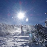
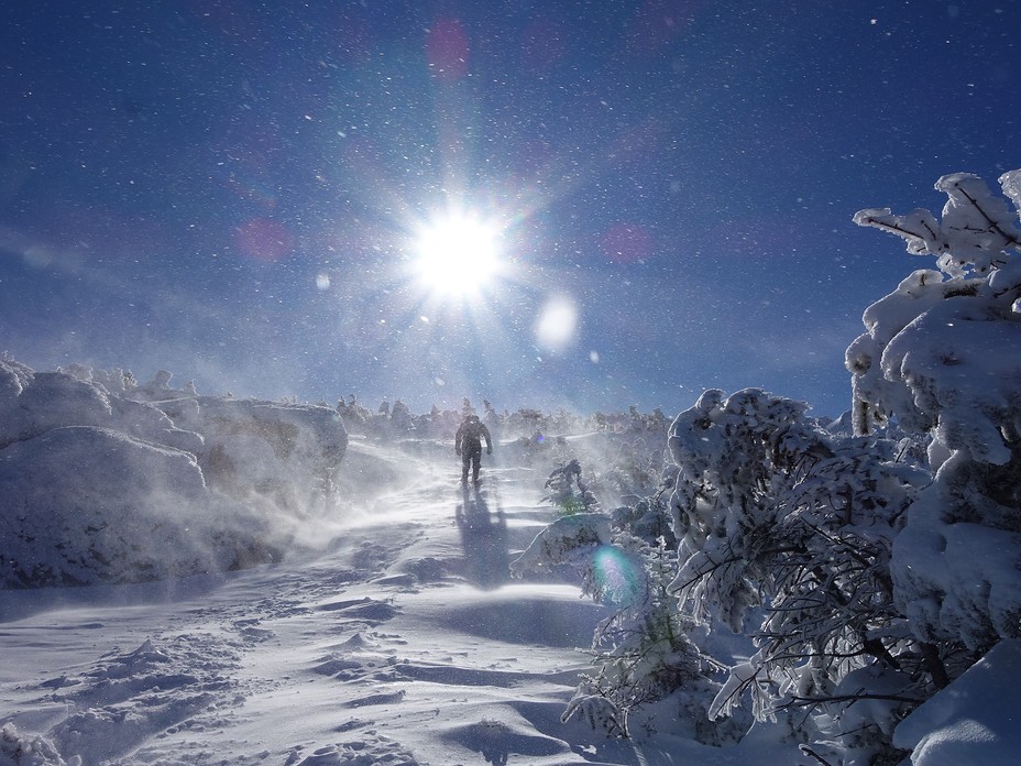
Summiting Algonquin Peak 2-15-20
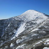
MONT ALGONQUIN
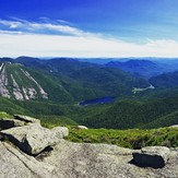
Algonquin from Wright
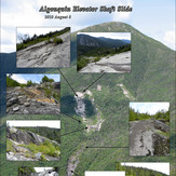
Algonquin Peak Elevator Shaft Slide