
– Lat/Long: 50.42° N 116.56° W
 Commander Mountain
Weather Forecast, CanadaIssued: 5 pm Thu 13 Jun Local TimeUpdates in: hr min sUpdate imminent
Commander MountainWeather Forecast, Canada
Issued: 5 pm Thu 13 Jun Local Time
Updates in:
Update imminent hr min s

Issued: 5 pm Thu 13 Jun Local Time
Updates in:
Update imminent hr min s
Days 1–4 Weather SummaryA moderate fall of snow, heaviest on Sat afternoon. Freeze-thaw conditions (max 1°C on Thu night, min -10°C on Sat night). Winds decreasing (strong winds from the SW on Fri afternoon, calm by Sun morning). | Days 5–7 Weather SummaryA moderate fall of snow, heaviest on Sun afternoon. Temperatures will be below freezing (max -2°C on Tue afternoon, min -8°C on Mon morning). Wind will be generally light. | ||||||||||||||||
Thu 13 | Friday 14 | Saturday 15 | Sunday 16 | Monday 17 | Tuesday 18 | ||||||||||||
PM | night | AM | PM | night | AM | PM | night | AM | PM | night | AM | PM | night | AM | PM | night | |
some clouds | some clouds | some clouds | some clouds | snow shwrs | light snow | mod. snow | light snow | light snow | light snow | light snow | some clouds | light snow | snow shwrs | clear | cloudy | snow shwrs | |
km/h | |||||||||||||||||
Wave Height Map |  | 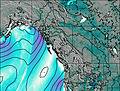 | 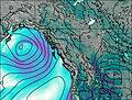 | 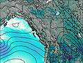 | 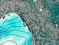 |  | |||||||||||
— | — | — | — | 1.0 | 3 | 7 | 4 | 2.0 | 4 | 5 | — | 2.0 | 1.0 | — | — | 1.0 | |
— | — | — | — | — | — | — | — | — | — | — | — | — | — | — | — | — | |
max°C | 0 | 1 | -2 | -1 | -4 | -7 | -8 | -9 | -8 | -7 | -7 | -7 | -5 | -5 | -4 | -2 | -2 |
min°C | -1 | -1 | -2 | -2 | -5 | -8 | -9 | -10 | -9 | -7 | -7 | -8 | -6 | -5 | -5 | -2 | -2 |
-5 | -7 | -8 | -9 | -11 | -14 | -15 | -16 | -12 | -10 | -11 | -13 | -11 | -10 | -9 | -6 | -5 | |
3250 | 3450 | 3100 | 3150 | 2700 | 2450 | 2250 | 1900 | 1950 | 2350 | 2250 | 2200 | 2650 | 2600 | 2650 | 3100 | 3100 | |
Cloud base (m) | 8700 | 5550 | 3450 | 2700 | 3150 | 2300 | 2250 | 2250 | 2250 | 2300 | 2250 | 2700 | 2950 | 3200 | 3250 | ||
— | — | 5:33 | — | — | 5:33 | — | — | 5:33 | — | — | 5:33 | — | — | 5:33 | — | — | |
— | 9:58 | — | — | 9:59 | — | — | 9:59 | — | — | 10:00 | — | — | 10:00 | — | — | 10:00 | |
Commander Mountain Weather (Days 0-3):
The weather forecast for Commander Mountain is: A moderate fall of snow, heaviest on Sat afternoon. Freeze-thaw conditions (max 1°C on Thu night, min -10°C on Sat night). Winds decreasing (strong winds from the SW on Fri afternoon, calm by Sun morning).
Commander Mountain Weather (Days 3-6):
A moderate fall of snow, heaviest on Sun afternoon. Temperatures will be below freezing (max -2°C on Tue afternoon, min -8°C on Mon morning). Wind will be generally light.
This table gives the weather forecast for Commander Mountain at the specific elevation of 3371 m. Our advanced weather models allow us to provide distinct weather forecasts for several elevations of Commander Mountain. To see the weather forecasts for the other elevations, use the tab navigation above the table. For a wider overview of the weather, consult the Weather Map of British-Columbia.
 Like us
 Follow us
