– Lat/Long: 45.87° N 6.99° E
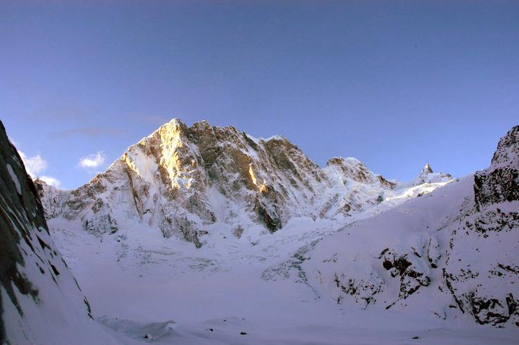
 Pointe Walker
Weather Forecast, FranceIssued: 1 pm Fri 14 Jun Local TimeUpdates in: hr min sUpdate imminent
Pointe WalkerWeather Forecast, France
Issued: 1 pm Fri 14 Jun Local Time
Updates in:
Update imminent hr min s

Issued: 1 pm Fri 14 Jun Local Time
Updates in:
Update imminent hr min s
Days 1–4 Weather SummaryA heavy fall of snow, heaviest during Sat morning. Temperatures will be below freezing (max -4°C on Fri night, min -7°C on Sat morning). Mainly fresh winds. | Days 5–7 Weather SummaryA light covering of new snow mostly falling on Wed afternoon. Freeze-thaw conditions (max 1°C on Tue night, min -2°C on Mon afternoon). Winds increasing (light winds from the SW on Tue morning, near gales from the SSW by Thu morning). | ||||||||||||||||
Fri 14 | Saturday 15 | Sunday 16 | Monday 17 | Tuesday 18 | Wednesday 19 | ||||||||||||
PM | night | AM | PM | night | AM | PM | night | AM | PM | night | AM | PM | night | AM | PM | night | |
light snow | snow shwrs | snow shwrs | snow shwrs | snow shwrs | some clouds | clear | clear | clear | some clouds | clear | clear | some clouds | clear | some clouds | snow shwrs | snow shwrs | |
km/h | |||||||||||||||||
Wave Height Map |  |  |  |  |  |  | |||||||||||
2.0 | 3 | 25 | 3 | 1.0 | — | — | — | — | — | — | — | — | — | — | 3 | 1.0 | |
— | — | — | — | — | — | — | — | — | — | — | — | — | — | — | — | — | |
max°C | -5 | -4 | -7 | -6 | -6 | -5 | -4 | -4 | -4 | -1 | -1 | -1 | 0 | 1 | 1 | 0 | 1 |
min°C | -6 | -6 | -7 | -7 | -7 | -6 | -5 | -4 | -4 | -2 | -2 | -1 | 0 | 0 | 1 | -1 | -1 |
-14 | -15 | -15 | -16 | -16 | -14 | -13 | -12 | -12 | -9 | -8 | -6 | -6 | -7 | -6 | -9 | -9 | |
3250 | 3650 | 3050 | 3300 | 3150 | 3250 | 3550 | 3500 | 3650 | 4000 | 4000 | 4100 | 4200 | 4400 | 4400 | 4250 | 4200 | |
Cloud base (m) | 2050 | 2100 | 2050 | 2300 | 6450 | 5250 | 2050 | 2150 | 3150 | 2350 | 2050 | 2050 | 2150 | ||||
— | — | 5:41 | — | — | 5:41 | — | — | 5:41 | — | — | 5:41 | — | — | 5:41 | — | — | |
— | 9:22 | — | — | 9:23 | — | — | 9:23 | — | — | 9:23 | — | — | 9:24 | — | — | 9:24 | |
Pointe Walker Weather (Days 0-3):
The weather forecast for Pointe Walker is: A heavy fall of snow, heaviest during Sat morning. Temperatures will be below freezing (max -4°C on Fri night, min -7°C on Sat morning). Mainly fresh winds.
Pointe Walker Weather (Days 3-6):
A light covering of new snow mostly falling on Wed afternoon. Freeze-thaw conditions (max 1°C on Tue night, min -2°C on Mon afternoon). Winds increasing (light winds from the SW on Tue morning, near gales from the SSW by Thu morning).
This table gives the weather forecast for Pointe Walker at the specific elevation of 4208 m. Our advanced weather models allow us to provide distinct weather forecasts for several elevations of Pointe Walker. To see the weather forecasts for the other elevations, use the tab navigation above the table. For a wider overview of the weather, consult the Weather Map of France.
Pointe Walker Photos
View all
Savoy Alps photos (118) |
Alps photos (1442) |
photos from mountains in France (267) |
all photos
 Upload new photo
Pointe Walker
 Like us
 Follow us
