– Lat/Long: 45.95° N 7.04° E
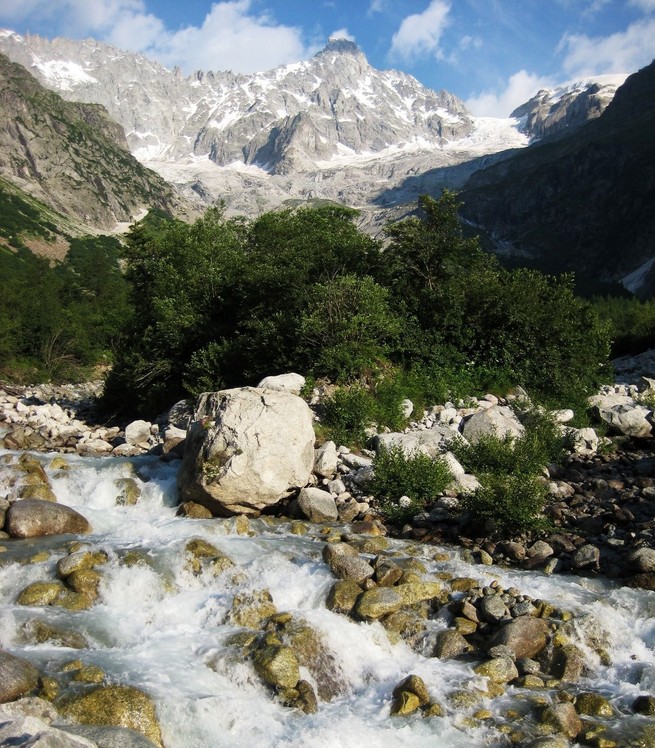
 Tour Noir
Weather Forecast, FranceIssued: 7 pm Sat 23 Aug Local TimeUpdates in: hr min sUpdate imminent
Issued: 7 pm Sat 23 Aug Local Time
Updates in:
Update imminent hr min s

Issued: 7 pm Sat 23 Aug Local Time
Updates in:
Update imminent hr min s
Days 1–4 Weather SummaryMostly dry. Freeze-thaw conditions (max 2°C on Tue afternoon, min -2°C on Sat night). Wind will be generally light. | Days 5–7 Weather SummaryLight rain (total 2mm) on Wed afternoon. Becoming colder with heavy fall of snow, heaviest during Thu morning. Freeze-thaw conditions (max 3°C on Wed afternoon, min -5°C on Fri morning). Winds decreasing (fresh winds from the S on Wed night, light winds from the SW by Fri morning). | ||||||||||||||||||
Sunday 24 | Monday 25 | Tuesday 26 | Wednesday 27 | Thursday 28 | Friday 29 | ||||||||||||||
night | AM | PM | night | AM | PM | night | AM | PM | night | AM | PM | night | AM | PM | night | AM | PM | night | |
clear | clear | clear | clear | clear | clear | clear | clear | some clouds | snow shwrs | some clouds | rain shwrs | snow shwrs | mod. snow | snow shwrs | heavy snow | snow shwrs | some clouds | light snow | |
km/h | |||||||||||||||||||
 |  |  |  |  |  |  | |||||||||||||
— | — | — | — | — | — | — | — | — | 1 | — | — | 5 | 10 | 10 | 13 | 1 | — | 4 | |
— | — | — | — | — | — | — | — | — | — | — | 1.3 | 0.8 | — | — | — | — | — | — | |
max°C | 0 | 0 | 0 | 1 | 1 | 1 | 0 | 1 | 2 | 2 | 2 | 3 | 3 | 0 | 0 | -1 | -4 | -2 | -4 |
min°C | -2 | 0 | -1 | 0 | 1 | 0 | 0 | 0 | 2 | 0 | 2 | 2 | 0 | -2 | -1 | -4 | -5 | -2 | -5 |
-8 | -5 | -6 | -5 | -3 | -4 | -4 | -4 | -2 | -4 | -2 | -2 | -7 | -8 | -7 | -11 | -11 | -7 | -13 | |
3750 | 3800 | 3750 | 3950 | 3900 | 4000 | 3850 | 3950 | 4200 | 3900 | 4200 | 4200 | 4200 | 3450 | 3700 | 3400 | 3300 | 3450 | 3200 | |
Cloud base (m) | 8400 | 9350 | 3700 | 2550 | 4450 | 2950 | 2550 | 2250 | 2450 | 2250 | 2400 | 3350 | 2550 | ||||||
— | 6:41 | — | — | 6:43 | — | — | 6:43 | — | — | 6:45 | — | — | 6:46 | — | — | 6:48 | — | — | |
— | — | — | 8:25 | — | — | 8:23 | — | — | 8:22 | — | — | 8:20 | — | — | 8:17 | — | — | 8:15 | |
Loading...
Tour Noir Weather (Days 0-3):
The weather forecast for Tour Noir is: Mostly dry. Freeze-thaw conditions (max 2°C on Tue afternoon, min -2°C on Sat night). Wind will be generally light.
Tour Noir Weather (Days 3-6):
Light rain (total 2mm) on Wed afternoon. Becoming colder with heavy fall of snow, heaviest during Thu morning. Freeze-thaw conditions (max 3°C on Wed afternoon, min -5°C on Fri morning). Winds decreasing (fresh winds from the S on Wed night, light winds from the SW by Fri morning).
This table gives the weather forecast for Tour Noir at the specific elevation of 3836 m. Our advanced weather models allow us to provide distinct weather forecasts for several elevations of Tour Noir. To see the weather forecasts for the other elevations, use the tab navigation above the table. For a wider overview of the weather, consult the Weather Map of France.
Tour Noir Photos
View all
Savoy Alps photos (138) |
Alps photos (1475) |
photos from mountains in France (296) |
all photos
 Upload new photo
Tour Noir