
– Lat/Long: 39.70° S 176.91° E
 Te Mata Peak
Weather Forecast, New ZealandIssued: 5 pm Tue 14 May Local TimeUpdates in: hr min sUpdate imminent
Te Mata PeakWeather Forecast, New Zealand
Issued: 5 pm Tue 14 May Local Time
Updates in:
Update imminent hr min s

Issued: 5 pm Tue 14 May Local Time
Updates in:
Update imminent hr min s
Days 1–4 Weather SummarySome drizzle, heaviest during Tue night. Very mild (max 18°C on Thu afternoon, min 10°C on Tue night). Wind will be generally light. | Days 5–7 Weather SummarySome drizzle, heaviest during Mon morning. Very mild (max 15°C on Sat afternoon, min 7°C on Fri night). Wind will be generally light. | Days 8–10 Weather SummaryModerate rain (total 19mm), heaviest on Wed afternoon. Very mild (max 15°C on Mon afternoon, min 9°C on Tue night). Wind will be generally light. | Days 11–13 Weather SummarySome drizzle, heaviest during Sat night. Very mild (max 18°C on Sat morning, min 7°C on Thu night). Wind will be generally light. | |||||||||||||||||||||||||||||||||
Tue 14 | Wednesday 15 | Thursday 16 | Friday 17 | Saturday 18 | Sunday 19 | Monday 20 | Tuesday 21 | Wednesday 22 | Thursday 23 | Friday 24 | Saturday 25 | Sun 26 | ||||||||||||||||||||||||
PM | night | AM | PM | night | AM | PM | night | AM | PM | night | AM | PM | night | AM | PM | night | AM | PM | night | AM | PM | night | AM | PM | night | AM | PM | night | AM | PM | night | AM | PM | night | AM | |
some clouds | rain shwrs | light rain | rain shwrs | rain shwrs | some clouds | clear | rain shwrs | some clouds | clear | clear | clear | clear | some clouds | some clouds | rain shwrs | rain shwrs | rain shwrs | rain shwrs | rain shwrs | rain shwrs | rain shwrs | some clouds | light rain | mod. rain | mod. rain | rain shwrs | some clouds | clear | clear | some clouds | some clouds | clear | some clouds | rain shwrs | rain shwrs | |
km/h | ||||||||||||||||||||||||||||||||||||
Wave Height Map |  |  |  |  |  |  | 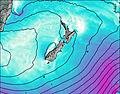 | 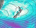 | 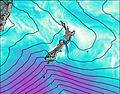 | 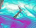 | 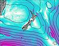 | 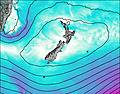 | 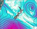 | |||||||||||||||||||||||
— | — | — | — | — | — | — | — | — | — | — | — | — | — | — | — | — | — | — | — | — | — | — | — | — | — | — | — | — | — | — | — | — | — | — | — | |
— | 0.3 | 0.6 | 0.2 | 0.1 | — | — | 0.1 | — | — | — | — | — | — | — | 0.2 | 0.7 | 1.0 | 0.5 | 1.0 | 0.6 | 0.3 | — | 0.7 | 9 | 7 | 0.1 | — | — | — | — | — | — | — | 0.8 | 0.4 | |
max°C | 13 | 11 | 13 | 15 | 14 | 17 | 18 | 13 | 14 | 14 | 12 | 14 | 15 | 10 | 14 | 13 | 13 | 15 | 15 | 12 | 13 | 14 | 10 | 10 | 10 | 11 | 12 | 12 | 9 | 15 | 15 | 12 | 18 | 18 | 12 | 12 |
min°C | 12 | 10 | 12 | 15 | 11 | 12 | 14 | 11 | 12 | 12 | 7 | 8 | 12 | 9 | 10 | 13 | 11 | 13 | 13 | 11 | 12 | 12 | 9 | 10 | 10 | 10 | 10 | 11 | 7 | 10 | 13 | 10 | 12 | 14 | 11 | 11 |
11 | 8 | 10 | 14 | 10 | 12 | 13 | 10 | 12 | 10 | 6 | 7 | 12 | 8 | 9 | 12 | 10 | 13 | 12 | 10 | 11 | 12 | 8 | 10 | 9 | 7 | 8 | 11 | 6 | 10 | 13 | 10 | 11 | 13 | 9 | 9 | |
2250 | 2400 | 2750 | 3050 | 2550 | 2250 | 2600 | 2100 | 2650 | 3000 | 3100 | 3050 | 2950 | 2850 | 2600 | 2550 | 2650 | 2550 | 2550 | 2600 | 2750 | 2700 | 2650 | 1950 | 1750 | 1500 | 1300 | 1500 | 2150 | 2150 | 2250 | 2150 | 2100 | 2150 | 1750 | 1400 | |
Cloud base (m) | 5950 | 200 | 300 | 400 | 750 | 1750 | 450 | 550 | 9600 | 400 | 8750 | 150 | 500 | 500 | 2000 | 650 | 450 | 600 | 1400 | 2100 | 50 | 100 | 450 | 600 | 1450 | 1600 | 700 | 2300 | 1600 | 400 | ||||||
— | — | 7:09 | — | — | 7:09 | — | — | 7:11 | — | — | 7:11 | — | — | 7:13 | — | — | 7:13 | — | — | 7:15 | — | — | 7:16 | — | — | 7:16 | — | — | 7:16 | — | — | 7:18 | — | — | 7:18 | |
5:07 | — | — | 5:07 | — | — | 5:06 | — | — | 5:05 | — | — | 5:04 | — | — | 5:02 | — | — | 5:02 | — | — | 5:01 | — | — | 5:00 | — | — | 5:00 | — | — | 5:00 | — | — | 4:59 | — | — | |
Te Mata Peak Weather (Days 0-3):
The weather forecast for Te Mata Peak is: Some drizzle, heaviest during Tue night. Very mild (max 18°C on Thu afternoon, min 10°C on Tue night). Wind will be generally light.
Te Mata Peak Weather (Days 3-6):
Some drizzle, heaviest during Mon morning. Very mild (max 15°C on Sat afternoon, min 7°C on Fri night). Wind will be generally light.
Te Mata Peak Weather (Days 6-9):
Moderate rain (total 19mm), heaviest on Wed afternoon. Very mild (max 15°C on Mon afternoon, min 9°C on Tue night). Wind will be generally light.
This table gives the weather forecast for Te Mata Peak at the specific elevation of 0 m. Our advanced weather models allow us to provide distinct weather forecasts for several elevations of Te Mata Peak. To see the weather forecasts for the other elevations, use the tab navigation above the table. For a wider overview of the weather, consult the Weather Map of New Zealand.
 Like us
 Follow us
