
– Lat/Long: 45.81° S 170.55° E
 Kapukataumahaka
Weather Forecast, New ZealandIssued: 5 am Mon 29 Apr Local TimeUpdates in: hr min sUpdate imminent
KapukataumahakaWeather Forecast, New Zealand
Issued: 5 am Mon 29 Apr Local Time
Updates in:
Update imminent hr min s

Issued: 5 am Mon 29 Apr Local Time
Updates in:
Update imminent hr min s
Days 1–3 Weather SummaryLight rain (total 9mm), mostly falling on Wed morning. Very mild (max 12°C on Mon afternoon, min 2°C on Wed afternoon). Winds increasing (calm on Tue afternoon, strong winds from the WSW by Wed night). | Days 4–6 Weather SummarySome drizzle, heaviest during Thu night. Mild temperatures (max 6°C on Fri night, min 2°C on Thu night). Winds decreasing (gales from the WSW on Thu night, light winds from the W by Sat night). | Days 7–9 Weather SummaryLight rain (total 4mm), mostly falling on Sun night. Mild temperatures (max 7°C on Sun morning, min 1°C on Mon morning). Winds decreasing (strong winds from the WSW on Mon morning, light winds from the SSW by Tue night). | Days 10–12 Weather SummarySome drizzle, heaviest during Fri night. Mild temperatures (max 9°C on Fri afternoon, min 4°C on Wed night). Wind will be generally light. | |||||||||||||||||||||||||||||||||
Monday 29 | Tuesday 30 | Wednesday 1 | Thursday 2 | Friday 3 | Saturday 4 | Sunday 5 | Monday 6 | Tuesday 7 | Wednesday 8 | Thursday 9 | Friday 10 | |||||||||||||||||||||||||
AM | PM | night | AM | PM | night | AM | PM | night | AM | PM | night | AM | PM | night | AM | PM | night | AM | PM | night | AM | PM | night | AM | PM | night | AM | PM | night | AM | PM | night | AM | PM | night | |
clear | clear | clear | clear | cloudy | light rain | mod. rain | light rain | cloudy | rain shwrs | light rain | rain shwrs | rain shwrs | some clouds | clear | clear | clear | clear | clear | clear | rain shwrs | rain shwrs | rain shwrs | rain shwrs | some clouds | rain shwrs | some clouds | clear | clear | clear | clear | clear | some clouds | some clouds | cloudy | rain shwrs | |
km/h | ||||||||||||||||||||||||||||||||||||
Wave Height Map | 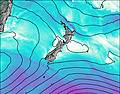 | 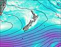 | 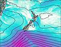 | 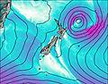 | 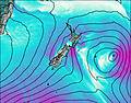 | 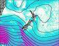 | 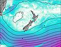 | 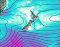 | 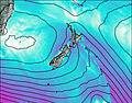 | 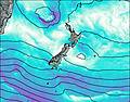 | 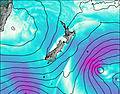 | 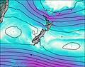 | ||||||||||||||||||||||||
— | — | — | — | — | — | — | — | — | — | — | — | — | — | — | — | — | — | — | — | — | — | — | — | — | — | — | — | — | — | — | — | — | — | — | — | |
— | — | — | — | — | 3 | 6 | 0.3 | — | 0.2 | 0.3 | 0.9 | 0.3 | — | — | — | — | — | — | — | 3 | 0.1 | 0.5 | 0.1 | — | 0.1 | — | — | — | — | — | — | — | — | — | 1.6 | |
max°C | 11 | 12 | 9 | 12 | 11 | 7 | 4 | 3 | 4 | 4 | 5 | 4 | 3 | 4 | 6 | 5 | 5 | 3 | 7 | 7 | 6 | 3 | 3 | 2 | 5 | 4 | 4 | 7 | 7 | 5 | 6 | 6 | 5 | 8 | 9 | 6 |
min°C | 8 | 9 | 9 | 9 | 9 | 5 | 4 | 2 | 2 | 3 | 5 | 2 | 2 | 4 | 5 | 5 | 4 | 3 | 4 | 6 | 2 | 1 | 3 | 2 | 3 | 4 | 3 | 5 | 5 | 4 | 4 | 5 | 4 | 5 | 7 | 5 |
5 | 8 | 8 | 8 | 8 | 1 | -1 | -4 | -4 | -4 | -2 | -6 | -5 | -2 | 0 | -2 | -2 | -3 | 1 | 2 | -5 | -6 | -3 | -4 | -1 | 0 | 0 | 4 | 4 | 3 | 4 | 4 | 4 | 4 | 6 | 2 | |
3000 | 3100 | 3050 | 2800 | 2400 | 2050 | 1250 | 1100 | 1150 | 1100 | 1200 | 1050 | 950 | 1200 | 2050 | 1250 | 1200 | 1200 | 2000 | 1800 | 1750 | 850 | 1000 | 950 | 1200 | 1350 | 1300 | 1550 | 1950 | 1950 | 1900 | 1850 | 1800 | 1800 | 1900 | 1650 | |
Cloud base (m) | 9500 | 9850 | 9700 | 2950 | 700 | 250 | 400 | 700 | 400 | 600 | 400 | 400 | 650 | 700 | 700 | 750 | 650 | 1550 | 600 | 800 | 650 | 550 | 350 | 750 | 900 | 850 | 1000 | 9550 | 950 | 1550 | 1750 | 2300 | 400 | |||
7:31 | — | — | 7:31 | — | — | 7:33 | — | — | 7:35 | — | — | 7:35 | — | — | 7:37 | — | — | 7:39 | — | — | 7:39 | — | — | 7:41 | — | — | 7:41 | — | — | 7:43 | — | — | 7:45 | — | — | |
— | 5:37 | — | — | 5:36 | — | — | 5:34 | — | — | 5:32 | — | — | 5:31 | — | — | 5:30 | — | — | 5:29 | — | — | 5:27 | — | — | 5:25 | — | — | 5:24 | — | — | 5:22 | — | — | 5:22 | — | |
Kapukataumahaka Weather (Days 0-3):
The weather forecast for Kapukataumahaka is: Light rain (total 9mm), mostly falling on Wed morning. Very mild (max 12°C on Mon afternoon, min 2°C on Wed afternoon). Winds increasing (calm on Tue afternoon, strong winds from the WSW by Wed night).
Kapukataumahaka Weather (Days 3-6):
Some drizzle, heaviest during Thu night. Mild temperatures (max 6°C on Fri night, min 2°C on Thu night). Winds decreasing (gales from the WSW on Thu night, light winds from the W by Sat night).
Kapukataumahaka Weather (Days 6-9):
Light rain (total 4mm), mostly falling on Sun night. Mild temperatures (max 7°C on Sun morning, min 1°C on Mon morning). Winds decreasing (strong winds from the WSW on Mon morning, light winds from the SSW by Tue night).
This table gives the weather forecast for Kapukataumahaka at the specific elevation of 676 m. Our advanced weather models allow us to provide distinct weather forecasts for several elevations of Kapukataumahaka. To see the weather forecasts for the other elevations, use the tab navigation above the table. For a wider overview of the weather, consult the Weather Map of New Zealand.
 Like us
 Follow us
