– Lat/Long: 36.97° S 70.70° W
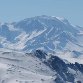
 Domuyo
Weather Forecast, ArgentinaIssued: 8 pm Tue 09 Jun Local TimeUpdates in: hr min sUpdate imminent
Issued: 8 pm Tue 09 Jun Local Time
Updates in:
Update imminent hr min s

Issued: 8 pm Tue 09 Jun Local Time
Updates in:
Update imminent hr min s
Days 1–4 Weather SummaryA heavy fall of snow, heaviest during Tue night. Extremely cold (max -13°C on Thu morning, min -19°C on Wed morning). Winds increasing (fresh winds from the WSW on Wed night, extremely windy from the WNW by Thu night). | Days 5–7 Weather SummaryA moderate fall of snow, heaviest on Fri night. Temperatures will be well below freezing (max -10°C on Sun afternoon, min -16°C on Fri night). Winds decreasing (gales from the WNW on Fri night, moderate winds from the SSW by Sat night). | ||||||||||||||||||
Wednesday 10 | Thursday 11 | Friday 12 | Saturday 13 | Sunday 14 | Monday 15 | ||||||||||||||
night | AM | PM | night | AM | PM | night | AM | PM | night | AM | PM | night | AM | PM | night | AM | PM | night | |
snow shwrs | clear | clear | some clouds | some clouds | clear | snow shwrs | snow shwrs | light snow | heavy snow | snow shwrs | clear | clear | clear | clear | clear | clear | clear | clear | |
km/h | |||||||||||||||||||
 |  |  |  |  |  |  | |||||||||||||
15 | — | — | — | — | — | 5 | 5 | 5 | 13 | 1 | — | — | — | — | — | — | — | — | |
— | — | — | — | — | — | — | — | — | — | — | — | — | — | — | — | — | — | — | |
max °C | -17 | -18 | -19 | -15 | -13 | -13 | -13 | -13 | -14 | -14 | -15 | -15 | -12 | -11 | -10 | -10 | -10 | -10 | -10 |
min °C | -18 | -19 | -19 | -19 | -14 | -13 | -14 | -14 | -14 | -16 | -15 | -15 | -14 | -11 | -11 | -10 | -10 | -10 | -11 |
-36 | -34 | -34 | -33 | -28 | -28 | -30 | -31 | -30 | -30 | -28 | -28 | -25 | -22 | -22 | -21 | -21 | -22 | -22 | |
1950 | 1850 | 2100 | 1950 | 1950 | 2550 | 1800 | 1500 | 2050 | 1950 | 2050 | 2350 | 1550 | 2850 | 3200 | 3300 | 3300 | 3300 | 3200 | |
Cloud base (m) | 1600 | 1600 | 1600 | 1650 | 1600 | 6550 | 1600 | 1800 | 1650 | 1600 | 1600 | 1650 | 1700 | ||||||
— | 8:52 | — | — | 8:52 | — | — | 8:52 | — | — | 8:52 | — | — | 8:52 | — | — | 8:53 | — | — | |
— | — | 6:31 | — | — | 6:31 | — | — | 6:31 | — | — | 6:31 | — | — | 6:31 | — | — | 6:31 | — | |
Loading...
Domuyo Weather (Days 0-3):
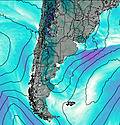
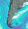
The weather forecast for Domuyo is: A heavy fall of snow, heaviest during Tue night. Extremely cold (max -13°C on Thu morning, min -19°C on Wed morning). Winds increasing (fresh winds from the WSW on Wed night, extremely windy from the WNW by Thu night).
Domuyo Weather (Days 3-6):
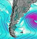
A moderate fall of snow, heaviest on Fri night. Temperatures will be well below freezing (max -10°C on Sun afternoon, min -16°C on Fri night). Winds decreasing (gales from the WNW on Fri night, moderate winds from the SSW by Sat night).
This table gives the weather forecast for Domuyo at the specific elevation of 4709 m. Our advanced weather models allow us to provide distinct weather forecasts for several elevations of Domuyo. To see the weather forecasts for the other elevations, use the tab navigation above the table. For a wider overview of the weather, consult the Weather Map of Argentina.
| Weather Station | Temp. | Weather | Wind | Gusts | Cloud / Visibility |
|---|---|---|---|---|---|
Chillán Mayulermo | |||||
Chillan | |||||
Malargue Airport | |||||
Concepcion Airport | |||||
Concepcion (85682 -0) | |||||
Temuco | |||||
Maquehue -Ufro | |||||
Nilahue - La Quebrada | |||||
Temuco Airport |
* NOTE: not all weather observatories update at the same frequency which is the reason why some locations may show data from stations that are further away than known closer ones.
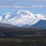
Domuyo Photos
View all
Patagonia photos (162) |
Andes photos (1027) |
photos from mountains in Argentina (251) |
all photos
 Upload new photo
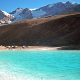

 See 13 more Domuyo photos
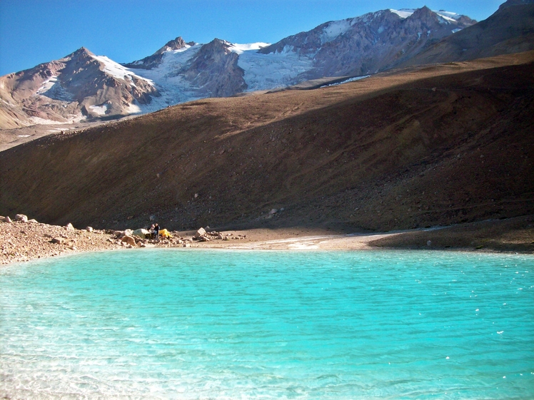
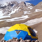
Campo base Vn. Domuyo (3000 msnm)
CRATER EXPEDICIONES Y LOGISTICA
CRATER EXPEDICIONES Y LOGISTICA
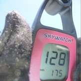
Domuyo 06/12/2013
Windy!
CRATER EXPEDICIONES Y LOGISTICA
Rumbo al Domuyo