
– Lat/Long: 35.63° N 83.48° W
 Chimney Tops
Weather Forecast, United StatesIssued: 1 am Tue 09 Jun Local TimeUpdates in: hr min sUpdate imminent
Issued: 1 am Tue 09 Jun Local Time
Updates in:
Update imminent hr min s

Issued: 1 am Tue 09 Jun Local Time
Updates in:
Update imminent hr min s
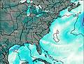
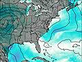
Days 1–3 Weather SummaryHeavy rain (total 32mm), heaviest during Tue night. Warm (max 21°C on Thu afternoon, min 17°C on Tue morning). Wind will be generally light. | Days 4–6 Weather SummaryModerate rain (total 11mm), heaviest on Fri night. Warm (max 22°C on Fri afternoon, min 16°C on Sun night). Winds increasing (light winds from the NNW on Fri night, fresh winds from the SE by Sat night). | |||||||||||||||||
Tuesday 9 | Wednesday 10 | Thursday 11 | Friday 12 | Saturday 13 | Sunday 14 | |||||||||||||
AM | PM | night | AM | PM | night | AM | PM | night | AM | PM | night | AM | PM | night | AM | PM | night | |
rain shwrs | risk tstorm | risk tstorm | rain shwrs | risk tstorm | risk tstorm | risk tstorm | risk tstorm | risk tstorm | rain shwrs | risk tstorm | risk tstorm | rain shwrs | clear | some clouds | clear | risk tstorm | rain shwrs | |
km/h | ||||||||||||||||||
 |  |  |  |  |  | |||||||||||||
— | — | — | — | — | — | — | — | — | — | — | — | — | — | — | — | — | — | |
3 | 7 | 6 | 0.8 | 7 | 1.6 | 0.1 | 4 | 3 | 1.2 | 0.2 | 4 | 0.2 | — | — | — | 3 | 3 | |
max °C | 17 | 18 | 18 | 18 | 19 | 19 | 19 | 21 | 20 | 19 | 22 | 21 | 18 | 21 | 20 | 19 | 20 | 17 |
min °C | 17 | 17 | 17 | 17 | 18 | 18 | 18 | 21 | 19 | 19 | 21 | 18 | 17 | 21 | 19 | 19 | 19 | 16 |
17 | 17 | 17 | 17 | 18 | 18 | 18 | 21 | 19 | 19 | 21 | 18 | 17 | 21 | 18 | 19 | 19 | 15 | |
4450 | 4600 | 4600 | 4650 | 4700 | 4800 | 4700 | 4650 | 4700 | 4650 | 4600 | 4750 | 4800 | 4850 | 4750 | 4600 | 4500 | 4550 | |
Cloud base (m) | 2300 | 1000 | 5400 | 1900 | 1700 | 8950 | 2200 | 2350 | 5250 | 600 | 6750 | 2100 | 3050 | |||||
6:16 | — | — | 6:16 | — | — | 6:16 | — | — | 6:16 | — | — | 6:16 | — | — | 6:16 | — | — | |
— | — | 8:47 | — | — | 8:49 | — | — | 8:49 | — | — | 8:49 | — | — | 8:50 | — | — | 8:50 | |
Loading...
Chimney Tops Weather (Days 0-3):
The weather forecast for Chimney Tops is: Heavy rain (total 32mm), heaviest during Tue night. Warm (max 21°C on Thu afternoon, min 17°C on Tue morning). Wind will be generally light.
Chimney Tops Weather (Days 3-6):
Moderate rain (total 11mm), heaviest on Fri night. Warm (max 22°C on Fri afternoon, min 16°C on Sun night). Winds increasing (light winds from the NNW on Fri night, fresh winds from the SE by Sat night).
This table gives the weather forecast for Chimney Tops at the specific elevation of 1463 m. Our advanced weather models allow us to provide distinct weather forecasts for several elevations of Chimney Tops. To see the weather forecasts for the other elevations, use the tab navigation above the table. For a wider overview of the weather, consult the Weather Map of Tennessee.
| Weather Station | Temp. | Weather | Wind | Gusts | Cloud / Visibility |
|---|---|---|---|---|---|
Gatlinburg Pigeon Forge Airport Sevierville (Tennessee) | |||||
* NOTE: not all weather observatories update at the same frequency which is the reason why some locations may show data from stations that are further away than known closer ones.