
– Lat/Long: 42.38° S 172.38° E
 Lewis Tops (Lewis-Pass)
Weather Forecast, New ZealandIssued: 11 am Wed 24 Apr Local TimeUpdates in: hr min sUpdate imminent
Lewis Tops (Lewis-Pass)Weather Forecast, New Zealand
Issued: 11 am Wed 24 Apr Local Time
Updates in:
Update imminent hr min s

Issued: 11 am Wed 24 Apr Local Time
Updates in:
Update imminent hr min s
Days 1–3 Weather SummaryModerate rain (total 15mm), heaviest on Thu afternoon giving way to a moderate fall of snow, heaviest on Thu night. Freeze-thaw conditions (max 6°C on Wed afternoon, min -3°C on Fri morning). Winds increasing (light winds from the WNW on Wed morning, gales from the NW by Thu morning). | Days 4–6 Weather SummaryMostly dry. Freeze-thaw conditions (max 5°C on Sun afternoon, min -1°C on Sat morning). Wind will be generally light. | Days 7–9 Weather SummaryA dusting of new snow. Freeze-thaw conditions (max 5°C on Tue afternoon, min -4°C on Wed afternoon). Wind will be generally light. | Days 10–12 Weather SummaryA dusting of new snow. Freeze-thaw conditions (max 5°C on Sun afternoon, min -1°C on Fri morning). Winds decreasing (strong winds from the W on Fri afternoon, calm by Sun afternoon). | |||||||||||||||||||||||||||||||||
Wednesday 24 | Thursday 25 | Friday 26 | Saturday 27 | Sunday 28 | Monday 29 | Tuesday 30 | Wednesday 1 | Thursday 2 | Friday 3 | Saturday 4 | Sunday 5 | |||||||||||||||||||||||||
AM | PM | night | AM | PM | night | AM | PM | night | AM | PM | night | AM | PM | night | AM | PM | night | AM | PM | night | AM | PM | night | AM | PM | night | AM | PM | night | AM | PM | night | AM | PM | night | |
clear | clear | rain shwrs | light rain | rain shwrs | snow shwrs | snow shwrs | snow shwrs | some clouds | some clouds | some clouds | clear | clear | clear | clear | clear | clear | clear | clear | clear | rain shwrs | some clouds | light snow | some clouds | some clouds | some clouds | cloudy | some clouds | snow shwrs | light snow | some clouds | clear | some clouds | clear | clear | some clouds | |
km/h | ||||||||||||||||||||||||||||||||||||
Wave Height Map | 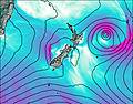 | 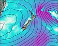 | 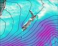 |  | 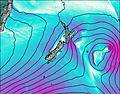 |  |  |  |  |  |  |  | ||||||||||||||||||||||||
— | — | — | — | — | 9 | 3 | 1.0 | — | — | — | — | — | — | — | — | — | — | — | — | — | — | 2.0 | — | — | — | — | — | 1.0 | 2.0 | — | — | — | — | — | — | |
— | — | 0.1 | 0.5 | 14 | 0.2 | — | — | — | — | — | — | — | — | — | — | — | — | — | — | 0.6 | — | — | — | — | — | — | — | — | — | — | — | — | — | — | — | |
max°C | 5 | 6 | 4 | 4 | 5 | 3 | -3 | -3 | -1 | 0 | 1 | 3 | 4 | 5 | 4 | 4 | 5 | 5 | 4 | 5 | 4 | 0 | -2 | -3 | -1 | -1 | 1 | 0 | 0 | 0 | 1 | 1 | 2 | 3 | 5 | 3 |
min°C | 3 | 5 | 3 | 4 | 3 | -1 | -3 | -3 | -2 | -1 | 0 | 2 | 3 | 4 | 4 | 4 | 4 | 4 | 3 | 4 | 1 | -1 | -4 | -4 | -3 | -1 | -1 | -1 | 0 | 0 | 0 | 1 | 1 | 2 | 4 | 2 |
0 | 2 | -3 | -4 | -4 | -9 | -12 | -10 | -7 | -4 | -2 | 1 | 1 | 3 | 3 | 1 | 1 | 1 | -1 | 0 | -4 | -4 | -7 | -4 | -7 | -7 | -7 | -8 | -7 | -6 | -4 | -2 | -2 | 0 | 2 | -2 | |
3800 | 3750 | 3600 | 3250 | 2550 | 1950 | 1200 | 1150 | 1150 | 1300 | 1750 | 2500 | 2850 | 3000 | 3050 | 3200 | 3250 | 3200 | 3150 | 3150 | 2250 | 1500 | 1200 | 900 | 1050 | 1350 | 1600 | 1500 | 1550 | 1550 | 1700 | 1950 | 2200 | 2100 | 2300 | 2150 | |
Cloud base (m) | 700 | 9750 | 700 | 650 | 600 | 800 | 650 | 650 | 800 | 700 | 900 | 2000 | 750 | 850 | 700 | 650 | 650 | 650 | 850 | 650 | 650 | 650 | 650 | 700 | 1550 | 900 | 850 | 1900 | 1850 | |||||||
7:11 | — | — | 7:13 | — | — | 7:13 | — | — | 7:15 | — | — | 7:16 | — | — | 7:16 | — | — | 7:18 | — | — | 7:18 | — | — | 7:20 | — | — | 7:20 | — | — | 7:22 | — | — | 7:24 | — | — | |
— | 5:44 | — | — | 5:43 | — | — | 5:40 | — | — | 5:39 | — | — | 5:37 | — | — | 5:37 | — | — | 5:36 | — | — | 5:34 | — | — | 5:32 | — | — | 5:31 | — | — | 5:30 | — | — | 5:29 | — | |
Lewis Tops (Lewis-Pass) Weather (Days 0-3):
The weather forecast for Lewis Tops (Lewis-Pass) is: Moderate rain (total 15mm), heaviest on Thu afternoon giving way to a moderate fall of snow, heaviest on Thu night. Freeze-thaw conditions (max 6°C on Wed afternoon, min -3°C on Fri morning). Winds increasing (light winds from the WNW on Wed morning, gales from the NW by Thu morning).
Lewis Tops (Lewis-Pass) Weather (Days 3-6):
Mostly dry. Freeze-thaw conditions (max 5°C on Sun afternoon, min -1°C on Sat morning). Wind will be generally light.
Lewis Tops (Lewis-Pass) Weather (Days 6-9):
A dusting of new snow. Freeze-thaw conditions (max 5°C on Tue afternoon, min -4°C on Wed afternoon). Wind will be generally light.
This table gives the weather forecast for Lewis Tops (Lewis-Pass) at the specific elevation of 1568 m. Our advanced weather models allow us to provide distinct weather forecasts for several elevations of Lewis Tops (Lewis-Pass). To see the weather forecasts for the other elevations, use the tab navigation above the table. For a wider overview of the weather, consult the Weather Map of New Zealand.
 Like us
 Follow us
