– Lat/Long: 40.60° N 111.68° W
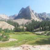
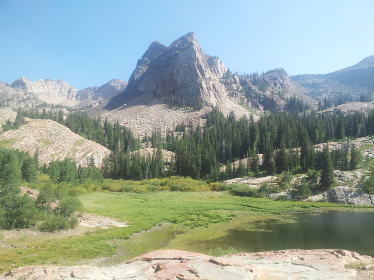
 Sundial Peak
Weather Forecast, United StatesIssued: 5 pm Mon 08 Jun Local TimeUpdates in: hr min sUpdate imminent
Issued: 5 pm Mon 08 Jun Local Time
Updates in:
Update imminent hr min s

Issued: 5 pm Mon 08 Jun Local Time
Updates in:
Update imminent hr min s
Days 1–4 Weather SummaryMostly dry. Freeze-thaw conditions (max 11°C on Mon night, min 0°C on Thu morning). Winds decreasing (gales from the SW on Mon night, calm by Thu morning). | Days 5–7 Weather SummaryMostly dry. Very mild (max 13°C on Sat afternoon, min 6°C on Thu afternoon). Wind will be generally light. | ||||||||||||||||
Mon 8 | Tuesday 9 | Wednesday 10 | Thursday 11 | Friday 12 | Saturday 13 | ||||||||||||
PM | night | AM | PM | night | AM | PM | night | AM | PM | night | AM | PM | night | AM | PM | night | |
some clouds | rain shwrs | light rain | risk tstorm | rain shwrs | clear | clear | clear | clear | clear | clear | clear | clear | clear | clear | clear | clear | |
km/h | |||||||||||||||||
 |  |  |  |  |  | ||||||||||||
— | — | — | — | — | — | — | — | — | — | — | — | — | — | — | — | — | |
— | 0.1 | 0.3 | 0.4 | 0.1 | — | — | — | — | — | — | — | — | — | — | — | — | |
max °C | 10 | 11 | 3 | 5 | 5 | 3 | 7 | 4 | 3 | 7 | 9 | 9 | 11 | 12 | 12 | 13 | 12 |
min °C | 9 | 6 | 3 | 4 | 2 | 2 | 6 | 1 | 0 | 6 | 7 | 9 | 11 | 11 | 11 | 13 | 12 |
5 | 1 | -4 | -1 | -4 | -4 | 1 | -4 | -3 | 6 | 6 | 6 | 9 | 10 | 10 | 11 | 10 | |
4400 | 4450 | 3550 | 3700 | 3700 | 3500 | 4100 | 3800 | 3200 | 4050 | 4350 | 4450 | 4550 | 4700 | 4600 | 4800 | 4800 | |
Cloud base (m) | 6900 | 5900 | 3400 | ||||||||||||||
— | — | 5:54 | — | — | 5:54 | — | — | 5:54 | — | — | 5:54 | — | — | 5:54 | — | — | |
8:54 | — | — | 8:55 | — | — | 8:55 | — | — | 8:57 | — | — | 8:57 | — | — | 8:58 | — | |
Loading...
Sundial Peak Weather (Days 0-3):
The weather forecast for Sundial Peak is: Mostly dry. Freeze-thaw conditions (max 11°C on Mon night, min 0°C on Thu morning). Winds decreasing (gales from the SW on Mon night, calm by Thu morning).
Sundial Peak Weather (Days 3-6):
Mostly dry. Very mild (max 13°C on Sat afternoon, min 6°C on Thu afternoon). Wind will be generally light.
This table gives the weather forecast for Sundial Peak at the specific elevation of 3146 m. Our advanced weather models allow us to provide distinct weather forecasts for several elevations of Sundial Peak. To see the weather forecasts for the other elevations, use the tab navigation above the table. For a wider overview of the weather, consult the Weather Map of Utah.