– Lat/Long: 53.07° N 4.07° W
 Snowdon
Weather Forecast, United KingdomIssued: 12 am Tue 09 Jun Local TimeUpdates in: hr min sUpdate imminent
Issued: 12 am Tue 09 Jun Local Time
Updates in:
Update imminent hr min s

Issued: 12 am Tue 09 Jun Local Time
Updates in:
Update imminent hr min s
Days 1–4 Weather SummaryHeavy rain (total 22mm), heaviest during Thu morning. Mild temperatures (max 9°C on Thu afternoon, min 2°C on Mon night). Winds decreasing (strong winds from the W on Tue morning, moderate winds from the W by Wed night). | Days 5–7 Weather SummarySome drizzle, heaviest during Thu night. Very mild (max 16°C on Sat morning, min 9°C on Thu night). Winds decreasing (strong winds from the WNW on Fri afternoon, light winds from the SSW by Sat afternoon). | ||||||||||||||||||
Tuesday 9 | Wednesday 10 | Thursday 11 | Friday 12 | Saturday 13 | Sunday 14 | ||||||||||||||
night | AM | PM | night | AM | PM | night | AM | PM | night | AM | PM | night | AM | PM | night | AM | PM | night | |
rain shwrs | rain shwrs | rain shwrs | rain shwrs | rain shwrs | rain shwrs | some clouds | mod. rain | mod. rain | light rain | light rain | clear | some clouds | some clouds | clear | clear | clear | clear | some clouds | |
km/h | |||||||||||||||||||
 |  |  |  |  |  |  | |||||||||||||
— | — | — | — | — | — | — | — | — | — | — | — | — | — | — | — | — | — | — | |
3 | 1.7 | 1.7 | 1.1 | 1.4 | 1 | — | 6 | 6 | 1.1 | 0.3 | — | — | — | — | — | — | — | — | |
max °C | 4 | 2 | 4 | 3 | 3 | 5 | 4 | 8 | 9 | 9 | 10 | 14 | 13 | 16 | 16 | 15 | 16 | 16 | 15 |
min °C | 2 | 2 | 3 | 2 | 3 | 4 | 3 | 6 | 9 | 9 | 10 | 14 | 12 | 14 | 16 | 15 | 15 | 15 | 14 |
-4 | -5 | -4 | -3 | -3 | -1 | -2 | 1 | 5 | 5 | 6 | 11 | 9 | 13 | 16 | 14 | 13 | 13 | 12 | |
1600 | 1400 | 1500 | 1500 | 1400 | 1550 | 1800 | 2600 | 3050 | 3400 | 3400 | 3750 | 3650 | 3500 | 3550 | 3650 | 3750 | 3850 | 3900 | |
Cloud base (m) | 650 | 400 | 700 | 1900 | 650 | 750 | 1800 | 250 | 300 | 300 | 300 | 300 | 450 | 6450 | 9200 | 9300 | |||
— | 4:50 | — | — | 4:50 | — | — | 4:50 | — | — | 4:50 | — | — | 4:48 | — | — | 4:48 | — | — | |
— | — | 9:38 | — | — | 9:39 | — | — | 9:40 | — | — | 9:42 | — | — | 9:42 | — | — | 9:43 | — | |
Loading...
Snowdon Weather (Days 0-3):
The weather forecast for Snowdon is: Heavy rain (total 22mm), heaviest during Thu morning. Mild temperatures (max 9°C on Thu afternoon, min 2°C on Mon night). Winds decreasing (strong winds from the W on Tue morning, moderate winds from the W by Wed night).
Snowdon Weather (Days 3-6):
Some drizzle, heaviest during Thu night. Very mild (max 16°C on Sat morning, min 9°C on Thu night). Winds decreasing (strong winds from the WNW on Fri afternoon, light winds from the SSW by Sat afternoon).
This table gives the weather forecast for Snowdon at the specific elevation of 1085 m. Our advanced weather models allow us to provide distinct weather forecasts for several elevations of Snowdon. To see the weather forecasts for the other elevations, use the tab navigation above the table. For a wider overview of the weather, consult the Weather Map of United Kingdom.
| Weather Station | Temp. | Weather | Wind | Gusts | Cloud / Visibility |
|---|---|---|---|---|---|
Caernarfon Airport | |||||
Valley RAF Airport | |||||
BARCIAL | |||||
HORNACHOS IM2 | |||||
* NOTE: not all weather observatories update at the same frequency which is the reason why some locations may show data from stations that are further away than known closer ones.
Snowdon Photos
View all
Snowdonia photos (205) |
Cambrian Mountains photos (383) |
photos from mountains in United Kingdom (2122) |
all photos
 Upload new photo
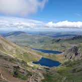
 See 66 more Snowdon photos
Views for miles
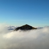
Snowdon trig
The view from the trig point
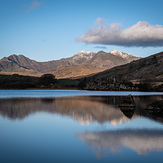
View from Llynau Mymbyr
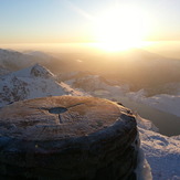
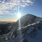
Rime Ice on Snowdon
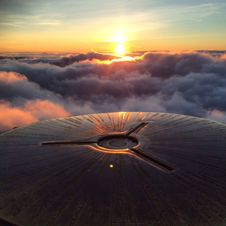
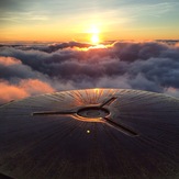
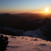
Stunning sunrise over Snowdon