– Lat/Long: 53.19° N 6.38° W
 Seefingan
Weather Forecast, IrelandIssued: 6 am Tue 23 Apr Local TimeUpdates in: hr min sUpdate imminent
SeefinganWeather Forecast, Ireland
Issued: 6 am Tue 23 Apr Local Time
Updates in:
Update imminent hr min s

Issued: 6 am Tue 23 Apr Local Time
Updates in:
Update imminent hr min s
Days 1–3 Weather SummaryLight rain (total 3mm) at first, then becoming colder with a dusting of snow on Thu night. Freeze-thaw conditions (max 7°C on Tue morning, min 0°C on Thu night). Wind will be generally light. | Days 4–6 Weather SummaryModerate rain (total 12mm), heaviest on Sat afternoon. Temperatures will be slightly above freezing (max 4°C on Sat afternoon, min 1°C on Fri morning). Winds decreasing (strong winds from the NE on Sat afternoon, calm by Sat night). | Days 7–9 Weather SummaryModerate rain (total 17mm), heaviest on Tue afternoon. Mild temperatures (max 7°C on Tue afternoon, min 2°C on Tue night). Winds decreasing (strong winds from the SSW on Tue morning, light winds from the NE by Wed night). | Days 10–12 Weather SummaryMostly dry. Very mild (max 11°C on Fri afternoon, min 7°C on Thu morning). Wind will be generally light. | |||||||||||||||||||||||||||||||||
Tuesday 23 | Wednesday 24 | Thursday 25 | Friday 26 | Saturday 27 | Sunday 28 | Monday 29 | Tuesday 30 | Wednesday 1 | Thursday 2 | Friday 3 | Saturday 4 | |||||||||||||||||||||||||
AM | PM | night | AM | PM | night | AM | PM | night | AM | PM | night | AM | PM | night | AM | PM | night | AM | PM | night | AM | PM | night | AM | PM | night | AM | PM | night | AM | PM | night | AM | PM | night | |
clear | clear | clear | some clouds | some clouds | some clouds | cloudy | light rain | light snow | cloudy | rain shwrs | rain shwrs | light rain | mod. rain | light rain | light rain | light rain | clear | rain shwrs | light rain | rain shwrs | light rain | mod. rain | light rain | rain shwrs | clear | clear | some clouds | rain shwrs | clear | clear | rain shwrs | rain shwrs | cloudy | some clouds | rain shwrs | |
km/h | ||||||||||||||||||||||||||||||||||||
Wave Height Map |  |  |  |  |  |  |  |  |  |  |  |  | ||||||||||||||||||||||||
— | — | — | — | — | — | — | — | 2.0 | — | — | — | — | — | — | — | — | — | — | — | — | — | — | — | — | — | — | — | — | — | — | — | — | — | — | — | |
— | — | — | — | — | — | — | 3 | — | — | 0.2 | 0.4 | 1.4 | 8 | 1.3 | 0.1 | 0.5 | — | 0.5 | 1.1 | 0.1 | 4 | 10 | 1.1 | 0.2 | — | — | — | 0.1 | — | — | 0.1 | 0.1 | — | — | 0.3 | |
max°C | 7 | 7 | 5 | 5 | 5 | 4 | 4 | 4 | 2 | 2 | 2 | 2 | 2 | 4 | 4 | 3 | 3 | 2 | 6 | 6 | 4 | 6 | 7 | 6 | 5 | 6 | 4 | 8 | 9 | 7 | 10 | 11 | 9 | 11 | 11 | 8 |
min°C | 6 | 7 | 2 | 4 | 5 | 1 | 3 | 2 | 0 | 1 | 2 | 1 | 2 | 3 | 3 | 3 | 2 | 2 | 5 | 6 | 4 | 5 | 6 | 2 | 3 | 5 | 4 | 7 | 9 | 7 | 9 | 11 | 8 | 11 | 10 | 7 |
2 | 4 | -3 | 0 | 3 | -4 | -1 | -1 | -4 | 1 | 1 | -3 | -4 | -4 | 3 | 1 | -4 | -2 | 1 | 2 | 0 | -1 | 1 | -2 | -2 | 1 | 1 | 4 | 7 | 7 | 8 | 10 | 7 | 9 | 7 | 4 | |
2200 | 1550 | 1950 | 1600 | 1300 | 1250 | 1250 | 1300 | 950 | 900 | 1050 | 1000 | 1050 | 1250 | 1400 | 1300 | 1050 | 1050 | 1300 | 1450 | 1500 | 1800 | 1800 | 1700 | 1150 | 1400 | 1700 | 1900 | 2300 | 2450 | 2500 | 2600 | 2750 | 2600 | 2500 | 2100 | |
Cloud base (m) | 8700 | 850 | 9200 | 200 | 750 | 850 | 350 | 100 | 150 | 350 | 100 | 250 | 100 | 100 | 100 | 100 | 100 | 700 | 750 | 800 | 500 | 450 | 100 | 100 | 250 | 700 | 850 | 800 | 550 | 2750 | 8700 | 800 | 5800 | 5900 | 2950 | 1500 |
6:07 | — | — | 6:05 | — | — | 6:03 | — | — | 6:01 | — | — | 5:58 | — | — | 5:56 | — | — | 5:54 | — | — | 5:52 | — | — | 5:50 | — | — | 5:48 | — | — | 5:47 | — | — | 5:45 | — | — | |
— | 8:39 | — | — | 8:42 | — | — | 8:44 | — | — | 8:45 | — | — | 8:47 | — | — | 8:49 | — | — | 8:51 | — | — | 8:52 | — | — | 8:54 | — | — | 8:55 | — | — | 8:58 | — | — | 9:00 | — | |
Seefingan Weather (Days 0-3):
The weather forecast for Seefingan is: Light rain (total 3mm) at first, then becoming colder with a dusting of snow on Thu night. Freeze-thaw conditions (max 7°C on Tue morning, min 0°C on Thu night). Wind will be generally light.
Seefingan Weather (Days 3-6):
Moderate rain (total 12mm), heaviest on Sat afternoon. Temperatures will be slightly above freezing (max 4°C on Sat afternoon, min 1°C on Fri morning). Winds decreasing (strong winds from the NE on Sat afternoon, calm by Sat night).
Seefingan Weather (Days 6-9):
Moderate rain (total 17mm), heaviest on Tue afternoon. Mild temperatures (max 7°C on Tue afternoon, min 2°C on Tue night). Winds decreasing (strong winds from the SSW on Tue morning, light winds from the NE by Wed night).
This table gives the weather forecast for Seefingan at the specific elevation of 724 m. Our advanced weather models allow us to provide distinct weather forecasts for several elevations of Seefingan. To see the weather forecasts for the other elevations, use the tab navigation above the table. For a wider overview of the weather, consult the Weather Map of Ireland.
| Weather Station | Temp. | Weather | Wind | Gusts | Cloud / Visibility |
|---|---|---|---|---|---|
Casement Air Base | |||||
Casement Aerodrome | |||||
Casement Aerodrome | |||||
* NOTE: not all weather observatories update at the same frequency which is the reason why some locations may show data from stations that are further away than known closer ones.
Seefingan Photos
View all
Wicklow Mountains photos (55) |
Ireland Ranges photos (306) |
photos from mountains in Ireland (358) |
all photos
 Upload new photo
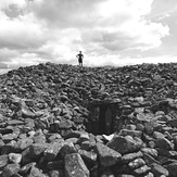
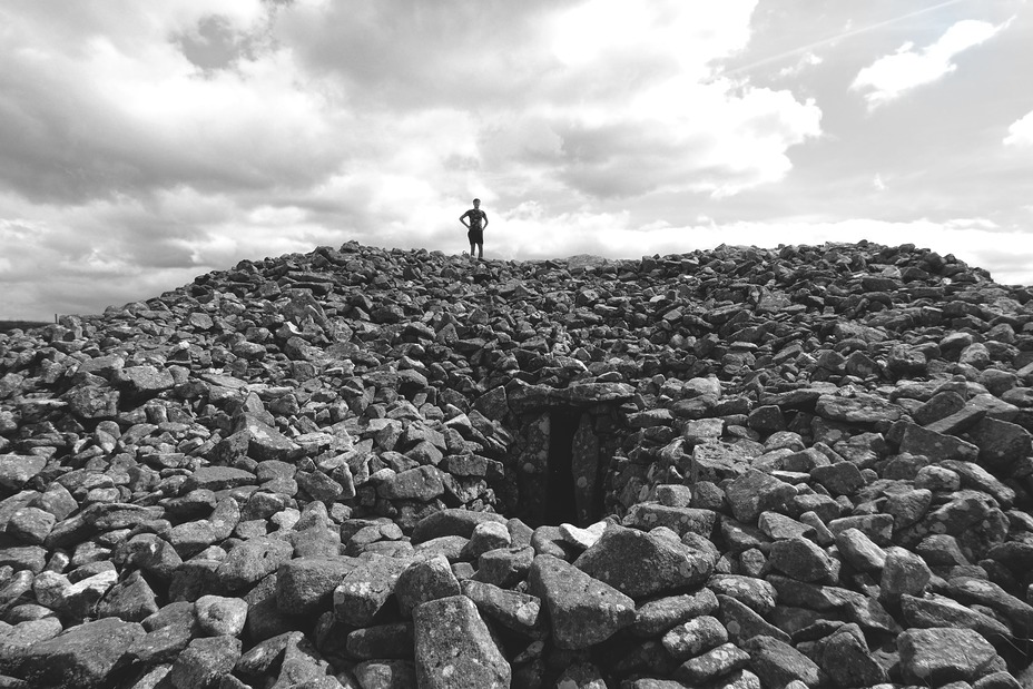
Seefin passage tomb
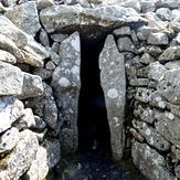
Passage Tomb Entrance
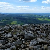
Cairn on Top
 Like us
 Follow us
