View
all Roys Peak photos (4) |
photos from Southern Alps (33) |
photos from New Zealand (109) |
photos from New Zealand (113) |
all photos
Roys Peak Photo: 'Roys Peak - Wanaka NZ - Summit Panorama' by Tim Harper
Roys Peak - Wanaka NZ - Summit Panorama
New Zealand | Roys Peak
| Average rating: 3.8 |
|
(use stars to vote) |
Summit view from Roys Peak. Wanaka township on right, looking north along the lake to Makarora in the middle. On left Glendhu Bay and the Matukituki valley, with Mt Aspiring in the distance. Track starts near the middle of the photo at the carpark (white area between the trees) and is a solid three hours uphill to 1578m. Farmland at the bottom, alpine tussocks at the summit. 2 knee-jarring hours back down.
 Upload new photo
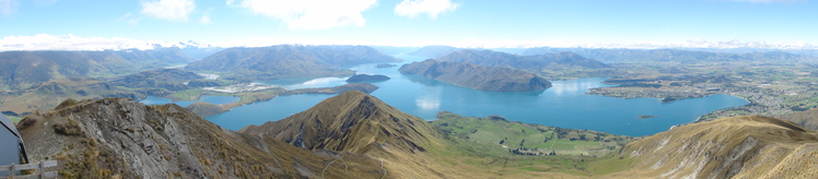
 Like us
 Follow us
