– Lat/Long: 42.92° N 0.08° E
 Pic Long
Weather Forecast, FranceIssued: 7 pm Wed 10 Jun Local TimeUpdates in: hr min sUpdate imminent
Issued: 7 pm Wed 10 Jun Local Time
Updates in:
Update imminent hr min s

Issued: 7 pm Wed 10 Jun Local Time
Updates in:
Update imminent hr min s
Days 1–4 Weather SummaryMostly dry. Mild temperatures (max 8°C on Fri night, min 2°C on Wed night). Winds decreasing (fresh winds from the NW on Thu morning, calm by Sat morning). | Days 5–7 Weather SummaryHeavy rain (total 20mm), heaviest during Mon afternoon. Mild temperatures (max 8°C on Sat night, min 4°C on Tue morning). Wind will be generally light. | ||||||||||||||||||
Thursday 11 | Friday 12 | Saturday 13 | Sunday 14 | Monday 15 | Tuesday 16 | ||||||||||||||
night | AM | PM | night | AM | PM | night | AM | PM | night | AM | PM | night | AM | PM | night | AM | PM | night | |
rain shwrs | clear | clear | clear | clear | clear | clear | clear | clear | clear | clear | some clouds | risk tstorm | some clouds | risk tstorm | risk tstorm | rain shwrs | risk tstorm | risk tstorm | |
km/h | |||||||||||||||||||
 |  |  |  |  |  |  | |||||||||||||
— | — | — | — | — | — | — | — | — | — | — | — | — | — | — | — | — | — | — | |
0.4 | — | — | — | — | — | — | — | — | — | — | — | 6 | — | 5 | 6 | 0.1 | 4 | 1.9 | |
max °C | 3 | 2 | 5 | 6 | 6 | 7 | 8 | 7 | 7 | 8 | 6 | 7 | 7 | 6 | 6 | 5 | 5 | 5 | 6 |
min °C | 2 | 2 | 3 | 5 | 6 | 6 | 7 | 7 | 7 | 7 | 6 | 7 | 6 | 6 | 5 | 5 | 4 | 5 | 6 |
-3 | -4 | -1 | 1 | 3 | 5 | 7 | 7 | 5 | 5 | 5 | 5 | 4 | 4 | 3 | 4 | 4 | 3 | 3 | |
3750 | 3600 | 4000 | 4150 | 4200 | 4300 | 4350 | 4250 | 4300 | 4200 | 4100 | 4150 | 4100 | 4050 | 3950 | 3950 | 3850 | 4000 | 4150 | |
Cloud base (m) | 850 | 850 | 9700 | 3650 | 3950 | 4300 | 1900 | 6050 | 2200 | 3450 | |||||||||
— | 6:20 | — | — | 6:20 | — | — | 6:20 | — | — | 6:20 | — | — | 6:20 | — | — | 6:20 | — | — | |
— | — | — | 9:37 | — | — | 9:37 | — | — | 9:38 | — | — | 9:38 | — | — | 9:39 | — | — | 9:39 | |
Loading...
Pic Long Weather (Days 0-3):
The weather forecast for Pic Long is: Mostly dry. Mild temperatures (max 8°C on Fri night, min 2°C on Wed night). Winds decreasing (fresh winds from the NW on Thu morning, calm by Sat morning).
Pic Long Weather (Days 3-6):
Heavy rain (total 20mm), heaviest during Mon afternoon. Mild temperatures (max 8°C on Sat night, min 4°C on Tue morning). Wind will be generally light.
This table gives the weather forecast for Pic Long at the specific elevation of 3192 m. Our advanced weather models allow us to provide distinct weather forecasts for several elevations of Pic Long. To see the weather forecasts for the other elevations, use the tab navigation above the table. For a wider overview of the weather, consult the Weather Map of France.
| Weather Station | Temp. | Weather | Wind | Gusts | Cloud / Visibility |
|---|---|---|---|---|---|
Candanchu | |||||
Pau -Uzein | |||||
Saint Girons | |||||
* NOTE: not all weather observatories update at the same frequency which is the reason why some locations may show data from stations that are further away than known closer ones.
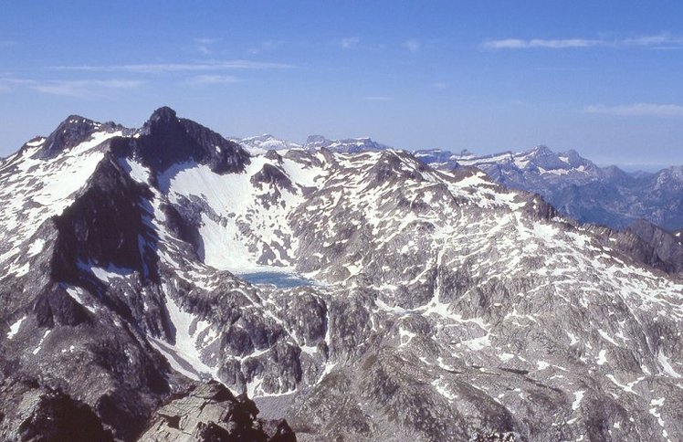
Pic Long Photos
View all
photos (101) |
Pyrenees photos (143) |
photos from mountains in France (301) |
all photos
 Upload new photo
Pic Long