
– Lat/Long: 47.27° N 10.65° E
 Muttekopf
Weather Forecast, AustriaIssued: 1 am Thu 18 Apr Local TimeUpdates in: hr min sUpdate imminent
MuttekopfWeather Forecast, Austria
Issued: 1 am Thu 18 Apr Local Time
Updates in:
Update imminent hr min s

Issued: 1 am Thu 18 Apr Local Time
Updates in:
Update imminent hr min s
Days 1–3 Weather SummaryModerate rain (total 13mm), heaviest on Fri night giving way to a moderate fall of snow, heaviest on Fri night. Freeze-thaw conditions (max 4°C on Fri morning, min -4°C on Thu night). Wind will be generally light. | Days 4–6 Weather SummaryA dusting of snow turning to light rain (total 4mm) on Tue night. Freeze-thaw conditions (max 5°C on Tue morning, min -7°C on Sun night). Wind will be generally light. | |||||||||||||||||
Thursday 18 | Friday 19 | Saturday 20 | Sunday 21 | Monday 22 | Tuesday 23 | |||||||||||||
AM | PM | night | AM | PM | night | AM | PM | night | AM | PM | night | AM | PM | night | AM | PM | night | |
some clouds | rain shwrs | some clouds | cloudy | light rain | light snow | light snow | light snow | mod. snow | light snow | light snow | some clouds | clear | rain shwrs | rain shwrs | some clouds | rain shwrs | light rain | |
km/h | ||||||||||||||||||
Wave Height Map | 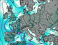 | 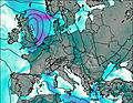 | 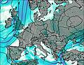 | 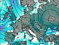 | 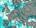 | 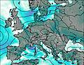 | ||||||||||||
— | — | — | — | — | 4 | 2.0 | 2.0 | 6 | 1.0 | 1.0 | — | — | — | — | — | — | — | |
— | 2 | — | — | 1.2 | 10 | — | — | — | — | — | — | — | 0.4 | 0.1 | — | 1.6 | 1.6 | |
max°C | 2 | 2 | -1 | 4 | 4 | 3 | 1 | 2 | 0 | 0 | 2 | -2 | 1 | 3 | 2 | 5 | 5 | 3 |
min°C | -2 | 2 | -4 | 0 | 3 | -1 | 0 | 2 | -3 | -1 | 1 | -7 | -4 | 3 | -2 | 1 | 5 | 1 |
-2 | -1 | -7 | -2 | 1 | -3 | -2 | 0 | -3 | -1 | -2 | -10 | -4 | 1 | -4 | 1 | 3 | 1 | |
1250 | 1350 | 500 | 1500 | 1500 | 1150 | 1150 | 1300 | 750 | 1050 | 1250 | 0 | 1200 | 1500 | 750 | 1700 | 1700 | 1250 | |
Cloud base (m) | 1600 | 2200 | 1600 | 1950 | 1550 | 1550 | 1850 | 1550 | 1550 | 1850 | 1600 | 1800 | 1650 | 1600 | 2250 | 1800 | 1550 | |
6:22 | — | — | 6:20 | — | — | 6:18 | — | — | 6:16 | — | — | 6:15 | — | — | 6:13 | — | — | |
— | — | 8:10 | — | — | 8:12 | — | — | 8:13 | — | — | 8:15 | — | — | 8:15 | — | — | 8:17 | |
Muttekopf Weather (Days 0-3):
The weather forecast for Muttekopf is: Moderate rain (total 13mm), heaviest on Fri night giving way to a moderate fall of snow, heaviest on Fri night. Freeze-thaw conditions (max 4°C on Fri morning, min -4°C on Thu night). Wind will be generally light.
Muttekopf Weather (Days 3-6):
A dusting of snow turning to light rain (total 4mm) on Tue night. Freeze-thaw conditions (max 5°C on Tue morning, min -7°C on Sun night). Wind will be generally light.
This table gives the weather forecast for Muttekopf at the specific elevation of 1000 m. Our advanced weather models allow us to provide distinct weather forecasts for several elevations of Muttekopf. To see the weather forecasts for the other elevations, use the tab navigation above the table. For a wider overview of the weather, consult the Weather Map of Austria.
 Like us
 Follow us
