Jorn Eriksson from NORWAY writes:
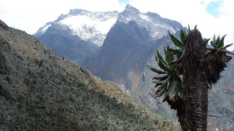
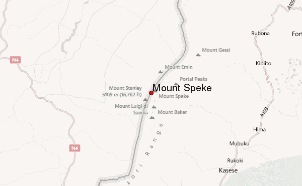
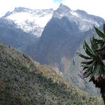
It normally takes 3 days to hike up to Bujuku Huts that are base camp for this climb. From Bujuku you need a full day for the climb. There are two normal routes (2013) to the summit. One is considerable longer but involves only scrambling Grade 3. The most common route is a grade 4 route and a rope should be carried, and put to use if ice and snow. Crampons and ice axe are needed on this trip. However we didn't use the crampons since the snow on the glacier was soft. It is recommended to use rope ascending and descending the crux of the route any way. In difference from Mt. Stanley there are no fixed ropes on Speke. We spent 5 hours climbing up including pauses, but I am not certain how long time we spent going down. It was just not a concern of mine. My guess is 3 hours. At Bujuku the elevation is 3960 amsl. at the summit it's 4890. That meant that we had to climb 930 altitude metres up to almost 5000 amsl. Obviously this would be a though day in this altitude. We started walking about 5 AM in complete darkness. First we ascended up to the Schulman pass following a good path. The slope was easy. At some point the path separates, and we turned right, and the terrain started to get steeper. Not long after we reached the first of the two sections where a rope should be considered on this route. However it was dry conditions, so we easily climbed up without. It was very dark, so it felt way more exposed than it really was. At the top of this slope we had to climb around a hanging three and then traverse in easy but exposed terrain until the slope got very gentle. In the west one could now view a wonderful lake (Lake Speke) on the Congo side. However we couldn't see it going up (We had clear and sunny weather going down) as a storm came over us. As we walked through some boulders heading for the crux of the route, a steep and icy upper section on the ridge we were now on, The wind was now so severe that we had serious doubts about continuing. We found shelter behind a huge rock and some discussion about what do to do. The most experienced guide put on crampons and the other guide went with him to secure him. The conditions were now extremely difficulty, and we watched with great concern. We didn't bring helmets on this trip, but that is something one always should consider, as a big rock came falling down towards us. Luckily we all escaped it. I was told that rock fall was not very common on this route, or in Rwenzori, but one never know. Anyway, he managed to put up the rope, and a student guide (we had 3 locals with us) climbed up the rope without using a prusik. The result was scary. the student had problems on the icy rocks getting good grips and almost fell. I was properly secured to rope behind and came the student to rescue. I used an ascender on the rope, and with this I had no problems climbing up. At the top of the rope, we stepped right and up an icy gully. We left the rope at the gully, and the rest of the climb was mostly a scramble with some exposed sections. It was still blowing strongly and we had little sight ahead. So our guide spent much time finding right way. At last we entered the snowfields on the upper glacier. The snow was soft, so we didn't put on the crampons. As we came closer to the summit the weather also became better, and suddenly we got some brief moments where we could see Mt. Baker. Bujuku valley, Congo and Mt. Stanley. We continued our scramble going left, and before I even realised it we were at the summit.
There was good flat area a few metres below the summit that gave good shelter for the wind, and room for the five of us to have something to eat. Going down we abseiled the two steep sections described earlier.
2013-03-20 |
 Mount Speke – Climbing, Hiking & Mountaineering information
 Like us
 Follow us
