– Lat/Long: 46.20° N 122.18° W
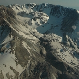
 Mount Saint Helens
Weather Forecast, United StatesIssued: 10 pm Mon 08 Jun Local TimeUpdates in: hr min sUpdate imminent
Issued: 10 pm Mon 08 Jun Local Time
Updates in:
Update imminent hr min s

Issued: 10 pm Mon 08 Jun Local Time
Updates in:
Update imminent hr min s
Days 1–4 Weather SummaryA heavy fall of snow, heaviest during Mon night. Freeze-thaw conditions (max 6°C on Thu afternoon, min -6°C on Tue night). Winds decreasing (gales from the WSW on Mon night, light winds from the WNW by Thu morning). | Days 5–7 Weather SummaryMostly dry. Very mild (max 13°C on Sun afternoon, min 6°C on Thu night). Winds decreasing (fresh winds from the NW on Fri afternoon, calm by Sun afternoon). | ||||||||||||||||||
Tuesday 9 | Wednesday 10 | Thursday 11 | Friday 12 | Saturday 13 | Sunday 14 | ||||||||||||||
night | AM | PM | night | AM | PM | night | AM | PM | night | AM | PM | night | AM | PM | night | AM | PM | night | |
heavy snow | mod. snow | light snow | light snow | cloudy | rain shwrs | clear | clear | clear | clear | clear | clear | clear | clear | clear | clear | clear | some clouds | clear | |
km/h | |||||||||||||||||||
 |  |  |  |  |  |  | |||||||||||||
14 | 7 | 3 | 4 | — | — | — | — | — | — | — | — | — | — | — | — | — | — | — | |
— | — | — | — | — | 0.1 | — | — | — | — | — | — | — | — | — | — | — | — | — | |
max °C | -1 | -3 | -4 | -4 | -2 | 2 | 3 | 4 | 6 | 6 | 7 | 9 | 8 | 9 | 10 | 12 | 12 | 13 | 14 |
min °C | -3 | -3 | -4 | -6 | -4 | 0 | 3 | 4 | 6 | 6 | 6 | 8 | 8 | 8 | 9 | 11 | 12 | 13 | 13 |
-13 | -12 | -13 | -16 | -13 | -5 | -2 | 0 | 3 | 2 | 2 | 4 | 4 | 6 | 8 | 10 | 11 | 13 | 13 | |
2200 | 2000 | 1900 | 1600 | 1850 | 3250 | 3450 | 3450 | 3650 | 3750 | 3950 | 4150 | 4100 | 3900 | 3850 | 4350 | 4500 | 4450 | 4750 | |
Cloud base (m) | 650 | 700 | 750 | 700 | 700 | 8450 | 9450 | 9150 | 8600 | ||||||||||
— | 5:16 | — | — | 5:16 | — | — | 5:16 | — | — | 5:16 | — | — | 5:16 | — | — | 5:16 | — | — | |
— | — | — | 8:58 | — | — | 8:59 | — | — | 8:59 | — | — | 9:00 | — | — | 9:00 | — | — | 9:00 | |
Loading...
Mount Saint Helens Weather (Days 0-3):
The weather forecast for Mount Saint Helens is: A heavy fall of snow, heaviest during Mon night. Freeze-thaw conditions (max 6°C on Thu afternoon, min -6°C on Tue night). Winds decreasing (gales from the WSW on Mon night, light winds from the WNW by Thu morning).
Mount Saint Helens Weather (Days 3-6):
Mostly dry. Very mild (max 13°C on Sun afternoon, min 6°C on Thu night). Winds decreasing (fresh winds from the NW on Fri afternoon, calm by Sun afternoon).
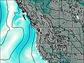
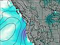
This table gives the weather forecast for Mount Saint Helens at the specific elevation of 2549 m. Our advanced weather models allow us to provide distinct weather forecasts for several elevations of Mount Saint Helens. To see the weather forecasts for the other elevations, use the tab navigation above the table. For a wider overview of the weather, consult the Weather Map of Washington.
| Weather Station | Temp. | Weather | Wind | Gusts | Cloud / Visibility |
|---|---|---|---|---|---|
Kelso Longveiw Airport | |||||
BUOY-KLMW1 | |||||
BUOY-LOPW1 | |||||
Vancouver Airport | |||||
Portland Airport | |||||
Ken Jernstedt Airfield - Hood River (Oregon) | |||||
* NOTE: not all weather observatories update at the same frequency which is the reason why some locations may show data from stations that are further away than known closer ones.
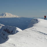
Mount Saint Helens Photos
View all
Cascade Range photos (448) |
Pacific Coast Ranges photos (1054) |
photos from mountains in United States (3050) |
all photos
 Upload new photo
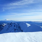
 See 40 more Mount Saint Helens photos
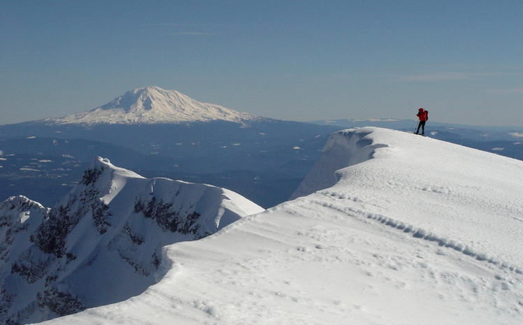
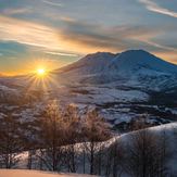
Mount St Helens
South Rim view...
Mount Saint Helens
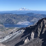
View of Rainier from South Rim
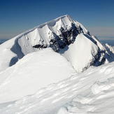
True Summit...
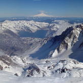
Inside the Crater...
Mt. St. Helens