
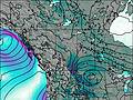
– Lat/Long: 50.78° N 115.21° W
 Mount Inflexible
Weather Forecast, CanadaIssued: 5 am Fri 12 Jun Local TimeUpdates in: hr min sUpdate imminent
Issued: 5 am Fri 12 Jun Local Time
Updates in:
Update imminent hr min s

Issued: 5 am Fri 12 Jun Local Time
Updates in:
Update imminent hr min s
Days 1–3 Weather SummaryA dusting of new snow. Freeze-thaw conditions (max 6°C on Sun afternoon, min -5°C on Fri night). Wind will be generally light. | Days 4–6 Weather SummaryLight rain (total 9mm) at first, then becoming colder with a dusting of snow on Tue night. Freeze-thaw conditions (max 7°C on Mon afternoon, min -1°C on Tue night). Winds decreasing (strong winds from the W on Mon afternoon, calm by Wed night). | |||||||||||||||||
Friday 12 | Saturday 13 | Sunday 14 | Monday 15 | Tuesday 16 | Wednesday 17 | |||||||||||||
AM | PM | night | AM | PM | night | AM | PM | night | AM | PM | night | AM | PM | night | AM | PM | night | |
light snow | light snow | some clouds | some clouds | clear | some clouds | some clouds | some clouds | some clouds | cloudy | some clouds | some clouds | rain shwrs | mod. rain | snow shwrs | clear | light rain | rain shwrs | |
km/h | ||||||||||||||||||
 |  |  |  |  |  | |||||||||||||
3 | 1 | — | — | — | — | — | — | — | — | — | — | — | — | 3 | — | — | — | |
— | — | — | — | — | — | — | — | — | — | — | — | 0.3 | 7 | — | — | 1.4 | 0.5 | |
max °C | -3 | -4 | -3 | -2 | 3 | 2 | 4 | 6 | 6 | 6 | 7 | 7 | 5 | 5 | 0 | 0 | 4 | 3 |
min °C | -4 | -4 | -5 | -2 | 1 | 2 | 2 | 6 | 5 | 5 | 6 | 4 | 4 | 2 | -1 | 0 | 2 | 2 |
-9 | -9 | -9 | -5 | 1 | 2 | 0 | 5 | 1 | 2 | 1 | -1 | 0 | -2 | -6 | -3 | -3 | 2 | |
2550 | 2550 | 2250 | 2650 | 3150 | 3400 | 3350 | 3800 | 3900 | 4000 | 4050 | 4000 | 3600 | 3700 | 3050 | 2950 | 3400 | 3400 | |
Cloud base (m) | 2550 | 2200 | 2350 | 5300 | 9150 | 6650 | 4550 | 5400 | 3350 | 3850 | 3050 | 3500 | 2200 | |||||
5:26 | — | — | 5:26 | — | — | 5:26 | — | — | 5:26 | — | — | 5:26 | — | — | 5:26 | — | — | |
— | — | 9:53 | — | — | 9:53 | — | — | 9:54 | — | — | 9:54 | — | — | 9:55 | — | — | 9:55 | |
Loading...
Mount Inflexible Weather (Days 0-3):
The weather forecast for Mount Inflexible is: A dusting of new snow. Freeze-thaw conditions (max 6°C on Sun afternoon, min -5°C on Fri night). Wind will be generally light.
Mount Inflexible Weather (Days 3-6):
Light rain (total 9mm) at first, then becoming colder with a dusting of snow on Tue night. Freeze-thaw conditions (max 7°C on Mon afternoon, min -1°C on Tue night). Winds decreasing (strong winds from the W on Mon afternoon, calm by Wed night).
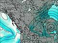
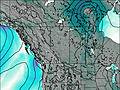
This table gives the weather forecast for Mount Inflexible at the specific elevation of 3000 m. Our advanced weather models allow us to provide distinct weather forecasts for several elevations of Mount Inflexible. To see the weather forecasts for the other elevations, use the tab navigation above the table. For a wider overview of the weather, consult the Weather Map of Alberta.
| Weather Station | Temp. | Weather | Wind | Gusts | Cloud / Visibility |
|---|---|---|---|---|---|
NakiskaRidgetop-Alta | |||||
BowValley-Alta | |||||
Banff Airport | |||||
BanffCs-Alta | |||||
Swansea Mtn | |||||
Black Diamond- Alta | |||||
CopUpper-Alta |
* NOTE: not all weather observatories update at the same frequency which is the reason why some locations may show data from stations that are further away than known closer ones.