– Lat/Long: 44.20° N 71.31° W
 Mount Davis (New Hampshire)
Weather Forecast, United StatesIssued: 7 pm Mon 08 Jun Local TimeUpdates in: hr min sUpdate imminent
Issued: 7 pm Mon 08 Jun Local Time
Updates in:
Update imminent hr min s

Issued: 7 pm Mon 08 Jun Local Time
Updates in:
Update imminent hr min s
Days 1–4 Weather SummaryModerate rain (total 11mm), heaviest on Wed afternoon. Very mild (max 19°C on Wed morning, min 13°C on Mon night). Wind will be generally light. | Days 5–7 Weather SummaryLight rain (total 4mm), mostly falling on Fri night. Very mild (max 18°C on Fri afternoon, min 10°C on Sun morning). Winds increasing (calm on Thu night, near gales from the WNW by Sun morning). | ||||||||||||||||||
Tuesday 9 | Wednesday 10 | Thursday 11 | Friday 12 | Saturday 13 | Sunday 14 | ||||||||||||||
night | AM | PM | night | AM | PM | night | AM | PM | night | AM | PM | night | AM | PM | night | AM | PM | night | |
clear | clear | some clouds | some clouds | some clouds | mod. rain | light rain | light rain | light rain | rain shwrs | rain shwrs | light rain | rain shwrs | rain shwrs | clear | clear | rain shwrs | rain shwrs | rain shwrs | |
km/h | |||||||||||||||||||
 |  |  |  |  |  |  | |||||||||||||
— | — | — | — | — | — | — | — | — | — | — | — | — | — | — | — | — | — | — | |
— | — | — | — | — | 5 | 4 | 1.2 | 0.9 | 0.1 | 0.3 | 0.3 | 1.8 | 0.8 | — | — | 0.6 | 0.2 | 0.1 | |
max °C | 14 | 16 | 18 | 17 | 19 | 18 | 18 | 16 | 17 | 17 | 17 | 18 | 17 | 15 | 17 | 14 | 10 | 11 | 10 |
min °C | 13 | 14 | 18 | 15 | 17 | 18 | 16 | 16 | 16 | 16 | 17 | 17 | 15 | 15 | 17 | 11 | 10 | 10 | 9 |
12 | 13 | 18 | 14 | 17 | 18 | 16 | 16 | 16 | 16 | 17 | 16 | 14 | 14 | 16 | 8 | 6 | 6 | 6 | |
4150 | 4250 | 4450 | 4450 | 4250 | 4250 | 4300 | 4300 | 4500 | 4450 | 4450 | 4550 | 4450 | 4200 | 3850 | 3350 | 3250 | 3450 | 3500 | |
Cloud base (m) | 7100 | 2150 | 900 | 1850 | 550 | 550 | 1650 | 1700 | 750 | 550 | 1750 | 1900 | |||||||
— | 5:01 | — | — | 5:01 | — | — | 5:01 | — | — | 5:01 | — | — | 5:01 | — | — | 5:01 | — | — | |
— | — | — | 8:27 | — | — | 8:27 | — | — | 8:28 | — | — | 8:29 | — | — | 8:29 | — | — | 8:30 | |
Loading...
Mount Davis (New Hampshire) Weather (Days 0-3):
The weather forecast for Mount Davis (New Hampshire) is: Moderate rain (total 11mm), heaviest on Wed afternoon. Very mild (max 19°C on Wed morning, min 13°C on Mon night). Wind will be generally light.
Mount Davis (New Hampshire) Weather (Days 3-6):
Light rain (total 4mm), mostly falling on Fri night. Very mild (max 18°C on Fri afternoon, min 10°C on Sun morning). Winds increasing (calm on Thu night, near gales from the WNW by Sun morning).
This table gives the weather forecast for Mount Davis (New Hampshire) at the specific elevation of 1164 m. Our advanced weather models allow us to provide distinct weather forecasts for several elevations of Mount Davis (New Hampshire). To see the weather forecasts for the other elevations, use the tab navigation above the table. For a wider overview of the weather, consult the Weather Map of New-Hampshire.
| Weather Station | Temp. | Weather | Wind | Gusts | Cloud / Visibility |
|---|---|---|---|---|---|
Mount Washington Airport | |||||
Whitefield Airport | |||||
Fryeburg Airport | |||||
Berlin Airport | |||||
* NOTE: not all weather observatories update at the same frequency which is the reason why some locations may show data from stations that are further away than known closer ones.
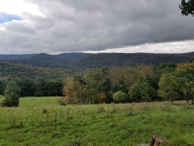
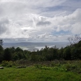
Mount Davis (New Hampshire) Photos
View all
White Mountains (New Hampshire) photos (182) |
Appalachians photos (907) |
photos from mountains in United States (3050) |
all photos
 Upload new photo
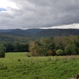
Fall coming
High point lake