– Lat/Long: 48.51° N 7.17° E
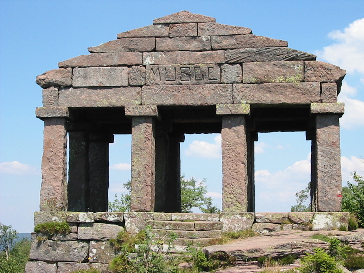
 Mont Donon
Weather Forecast, FranceIssued: 7 am Tue 09 Jun Local TimeUpdates in: hr min sUpdate imminent
Issued: 7 am Tue 09 Jun Local Time
Updates in:
Update imminent hr min s

Issued: 7 am Tue 09 Jun Local Time
Updates in:
Update imminent hr min s
Days 1–3 Weather SummaryModerate rain (total 11mm), heaviest on Wed afternoon. Very mild (max 11°C on Tue afternoon, min 5°C on Wed night). Mainly fresh winds. | Days 4–6 Weather SummaryLight rain (total 4mm), mostly falling on Fri night. Very mild (max 18°C on Sun afternoon, min 7°C on Fri morning). Wind will be generally light. | |||||||||||||||||
Tuesday 9 | Wednesday 10 | Thursday 11 | Friday 12 | Saturday 13 | Sunday 14 | |||||||||||||
AM | PM | night | AM | PM | night | AM | PM | night | AM | PM | night | AM | PM | night | AM | PM | night | |
rain shwrs | rain shwrs | cloudy | light rain | rain shwrs | risk tstorm | rain shwrs | light rain | light rain | cloudy | light rain | light rain | rain shwrs | light rain | rain shwrs | clear | clear | clear | |
km/h | ||||||||||||||||||
 |  |  |  |  |  | |||||||||||||
— | — | — | — | — | — | — | — | — | — | — | — | — | — | — | — | — | — | |
3 | 0.1 | — | 1.6 | 4 | 2 | 0.3 | 0.1 | 0.3 | — | 1.1 | 1.6 | 0.6 | 0.9 | 0.2 | — | — | — | |
max °C | 7 | 11 | 9 | 8 | 7 | 8 | 7 | 9 | 8 | 8 | 10 | 10 | 12 | 15 | 15 | 15 | 18 | 17 |
min °C | 7 | 9 | 7 | 7 | 6 | 5 | 6 | 8 | 7 | 7 | 9 | 10 | 11 | 14 | 12 | 13 | 17 | 14 |
3 | 5 | 5 | 4 | 2 | 1 | 2 | 4 | 4 | 4 | 6 | 8 | 11 | 14 | 11 | 12 | 17 | 13 | |
2200 | 2550 | 2300 | 2000 | 2050 | 2050 | 1900 | 2300 | 2200 | 2800 | 3100 | 3100 | 3550 | 3700 | 3650 | 3600 | 3650 | 3800 | |
Cloud base (m) | 600 | 1950 | 2050 | 2350 | 450 | 2300 | 900 | 1850 | 2450 | 450 | 450 | 450 | 800 | 900 | 9450 | 650 | ||
5:30 | — | — | 5:28 | — | — | 5:28 | — | — | 5:28 | — | — | 5:28 | — | — | 5:28 | — | — | |
— | — | 9:30 | — | — | 9:30 | — | — | 9:31 | — | — | 9:32 | — | — | 9:32 | — | — | 9:34 | |
Loading...
Mont Donon Weather (Days 0-3):
The weather forecast for Mont Donon is: Moderate rain (total 11mm), heaviest on Wed afternoon. Very mild (max 11°C on Tue afternoon, min 5°C on Wed night). Mainly fresh winds.
Mont Donon Weather (Days 3-6):
Light rain (total 4mm), mostly falling on Fri night. Very mild (max 18°C on Sun afternoon, min 7°C on Fri morning). Wind will be generally light.
This table gives the weather forecast for Mont Donon at the specific elevation of 1008 m. Our advanced weather models allow us to provide distinct weather forecasts for several elevations of Mont Donon. To see the weather forecasts for the other elevations, use the tab navigation above the table. For a wider overview of the weather, consult the Weather Map of France.
| Weather Station | Temp. | Weather | Wind | Gusts | Cloud / Visibility |
|---|---|---|---|---|---|
DCC Altenberg | |||||
DCC_Fille Morte | |||||
Strasbourg -Entzheim | |||||
DCC Brezouard | |||||
Colmar Houssen Airport | |||||
Lahr Air Force Base Airport | |||||
Berghaupten ODGFe.V. |
* NOTE: not all weather observatories update at the same frequency which is the reason why some locations may show data from stations that are further away than known closer ones.
Mont Donon Photos
View all
Minor ranges of Europe photos (96) |
photos from mountains in France (301) |
all photos
 Upload new photo
Mont Donon