– Lat/Long: 61.59° N 148.90° W
 Matanuska Peak or Byers Peak – Climbing Notes
Matanuska Peak or Byers Peak – Climbing Notes
Matanuska Peak or Byers Peak Climbing notes shared by Mountain-Forecast users
Click here to submit your own climbing note for Matanuska Peak or Byers Peak
(NOTE: Texts may be edited by our content team for the purposes of ensuring accurate and relevant information)
-
February 03, 2013
Justin Saunders from United States
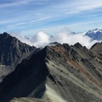
I prefer the old McRoberts Creek trail when climbing Byers. There is a new spur trail off of that one that ascends Lazy Mountain, from which you can trace the ridge to Byers, but it's longer and you miss out on a rewarding hike through the bowl. I just finished my first winter ascent on 2/2/2013. It's hard enough finding your footing in those loose rocks in the summer when there isn't any snow concealing the terrain. It was slow going with the added challenge of snow and ice. 6 hours to the top, another 2.5 to get down. That's a fair bit longer than a summer ascent, but worth every minute.
(NOTE: Texts may be edited by our content team for the purposes of ensuring accurate and relevant information)
Justin Saunders from United States
I prefer the old McRoberts Creek trail when climbing Byers. There is a new spur trail off of that one that ascends Lazy Mountain, from which you can trace the ridge to Byers, but it's longer and you miss out on a rewarding hike through the bowl. I just finished my first winter ascent on 2/2/2013. It's hard enough finding your footing in those loose rocks in the summer when there isn't any snow concealing the terrain. It was slow going with the added challenge of snow and ice. 6 hours to the top, another 2.5 to get down. That's a fair bit longer than a summer ascent, but worth every minute.
 Like us
 Follow us
