
– Lat/Long: 28.55° N 84.57° E
 Manaslu
Weather Forecast, NepalIssued: 4 pm Thu 11 Jun Local TimeUpdates in: hr min sUpdate imminent
Issued: 4 pm Thu 11 Jun Local Time
Updates in:
Update imminent hr min s

Issued: 4 pm Thu 11 Jun Local Time
Updates in:
Update imminent hr min s
Days 1–4 Weather SummaryA moderate fall of snow, heaviest on Fri afternoon. Extremely cold (max -17°C on Thu afternoon, min -19°C on Thu night). Mainly fresh winds. | Days 5–7 Weather SummaryA moderate fall of snow, heaviest on Sun night. Extremely cold (max -13°C on Tue night, min -17°C on Sun afternoon). Wind will be generally light. | ||||||||||||||||
Thu 11 | Friday 12 | Saturday 13 | Sunday 14 | Monday 15 | Tuesday 16 | ||||||||||||
PM | night | AM | PM | night | AM | PM | night | AM | PM | night | AM | PM | night | AM | PM | night | |
snow shwrs | snow shwrs | snow shwrs | light snow | some clouds | snow shwrs | light snow | some clouds | snow shwrs | snow shwrs | snow shwrs | snow shwrs | snow shwrs | snow shwrs | snow shwrs | snow shwrs | some clouds | |
km/h | |||||||||||||||||
 |  |  |  |  |  | ||||||||||||
2 | 2 | 1 | 4 | — | 1 | 2 | — | 1 | 1 | 4 | 1 | 1 | 1 | 1 | 1 | — | |
— | — | — | — | — | — | — | — | — | — | — | — | — | — | — | — | — | |
max °C | -17 | -17 | -18 | -17 | -18 | -18 | -17 | -17 | -18 | -16 | -16 | -17 | -15 | -15 | -15 | -14 | -13 |
min °C | -18 | -19 | -19 | -18 | -18 | -18 | -18 | -18 | -18 | -17 | -17 | -17 | -16 | -15 | -15 | -15 | -14 |
-26 | -29 | -29 | -27 | -28 | -26 | -28 | -28 | -29 | -25 | -23 | -25 | -23 | -20 | -24 | -24 | -21 | |
5200 | 4750 | 5200 | 5100 | 5000 | 5300 | 5250 | 5050 | 5300 | 5450 | 5150 | 5400 | 5550 | 5350 | 5700 | 5700 | 5550 | |
Cloud base (m) | 4500 | 4550 | 4650 | ||||||||||||||
— | — | 5:07 | — | — | 5:07 | — | — | 5:07 | — | — | 5:07 | — | — | 5:07 | — | — | |
7:04 | — | — | 7:04 | — | — | 7:05 | — | — | 7:05 | — | — | 7:05 | — | — | 7:06 | — | |
Loading...
Manaslu Weather (Days 0-3):
The weather forecast for Manaslu is: A moderate fall of snow, heaviest on Fri afternoon. Extremely cold (max -17°C on Thu afternoon, min -19°C on Thu night). Mainly fresh winds.
Manaslu Weather (Days 3-6):
A moderate fall of snow, heaviest on Sun night. Extremely cold (max -13°C on Tue night, min -17°C on Sun afternoon). Wind will be generally light.
This table gives the weather forecast for Manaslu at the specific elevation of 8156 m. Our advanced weather models allow us to provide distinct weather forecasts for several elevations of Manaslu. To see the weather forecasts for the other elevations, use the tab navigation above the table. For a wider overview of the weather, consult the Weather Map of Nepal.
| Weather Station | Temp. | Weather | Wind | Gusts | Cloud / Visibility |
|---|---|---|---|---|---|
Pakyong Airport- Pakyong | |||||
Baghdogra (in-af | |||||
Paro International Airport | |||||
* NOTE: not all weather observatories update at the same frequency which is the reason why some locations may show data from stations that are further away than known closer ones.
Manaslu Photos
View all
Central Nepal Himalaya photos (198) |
Greater Himalaya photos (359) |
photos from mountains in Nepal (283) |
all photos
 Upload new photo
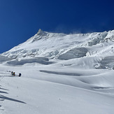
 See 17 more Manaslu photos
ALTITUDE JUNKIES PVT
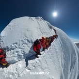
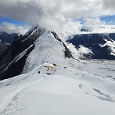
Manaslu Final Summit Point
ALTITUDE JUNKIES
ALTITUDE JUNKIES
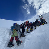
Manaslu camp-1
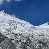
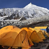
Manaslu base camp
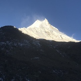
Mount Manaslu