 Knockmealdown – Climbing Notes
Knockmealdown – Climbing Notes
Knockmealdown Climbing notes shared by Mountain-Forecast users
Click here to submit your own climbing note for Knockmealdown
(NOTE: Texts may be edited by our content team for the purposes of ensuring accurate and relevant information)
-
August 02, 2012
Clogheen Tipp from Ireland
If you are just looking for some nice walks around the Knockmealdown Mountains (not necessarily up the mountains) then you should visit clogheen.net/walks and knockmealdownactive.com/active/walks. Both have a selection of walks around the foothills of the mountain range all the way from Ballyporeen, through Clogheen and Goatenbridge and on to Newcastle.
-
August 30, 2011
Waterford's mountains from Ireland
In very clear conditions the high Kerry mountains can be seen from Knockmealdown summit. Knockshanahullion summit in the west of the range has a lovely shelter built in to the summit cairn to give shelter from the elements.
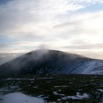
The Knockmealdown Mountains are a mountain range located on the border of counties South Tipperary and Waterford in Ireland, running east and west between the two counties. The highest peak of the range is Knockmealdown, situated in County Waterford. On the western side of the summit, the range is crossed by a high pass through which runs the old mail coach road from Lismore to Clogheen.
Name
Knockmealdown has two interpretations of the Irish origins of its name, either Cnoc Mhaoldomhnaigh: Muldowneys' Hill or Cnoc Maol Donn: bald brown hill.
Mountain peaks
List of peaks in the Knockmealdown Mountains ordered by height:
Knockmealdown (794 m)
Knockmoylan (768 m)
Knocknafallia (668 m)
Sugarloaf Hill (663 m)
Knocknagnauv (655 m)
Knockshanahullion (652 m)
Knocknalougha (630 m)
Knockmeal (560 m)
Crohan West (521 m)
Farbreaga (518 m)
-
July 28, 2011
Waterford's Mountains from Ireland
Much drier walking then the neighbouring Comeragh & Galtee mountain ranges. County Waterford's highest mountain is Knockmealdown 794metres(2,610feet. A stone boundary wall dividing the two counties of Tipperary and Waterford runs along much of the spine of the mountain range making an easy hand rail when weather conditions deteriorate. The north face of Knockmealdown peak itself is very steep and care is required on windy slippery conditions. If conditions get too bad quick access to roads R668 and R669 can be made by descending the slopes in a southerly and westerly direction.One mistake that can be made is descending the mountain to the North in places as much of the northern slopes are covered in thick coniferous forest as are the Western foothills in Counties Cork,Waterford and Tipperary. Often when the neighbouring Comeragh range is cloaked in cloud and fog the Knockmealdowns are clear. In very clear conditions views can extend as far West as the high mountains of Kerry.
(NOTE: Texts may be edited by our content team for the purposes of ensuring accurate and relevant information)
Clogheen Tipp from Ireland
If you are just looking for some nice walks around the Knockmealdown Mountains (not necessarily up the mountains) then you should visit clogheen.net/walks and knockmealdownactive.com/active/walks. Both have a selection of walks around the foothills of the mountain range all the way from Ballyporeen, through Clogheen and Goatenbridge and on to Newcastle.
Waterford's mountains from Ireland
In very clear conditions the high Kerry mountains can be seen from Knockmealdown summit. Knockshanahullion summit in the west of the range has a lovely shelter built in to the summit cairn to give shelter from the elements.
The Knockmealdown Mountains are a mountain range located on the border of counties South Tipperary and Waterford in Ireland, running east and west between the two counties. The highest peak of the range is Knockmealdown, situated in County Waterford. On the western side of the summit, the range is crossed by a high pass through which runs the old mail coach road from Lismore to Clogheen.
Name
Knockmealdown has two interpretations of the Irish origins of its name, either Cnoc Mhaoldomhnaigh: Muldowneys' Hill or Cnoc Maol Donn: bald brown hill.
Mountain peaks
List of peaks in the Knockmealdown Mountains ordered by height:
Knockmealdown (794 m)
Knockmoylan (768 m)
Knocknafallia (668 m)
Sugarloaf Hill (663 m)
Knocknagnauv (655 m)
Knockshanahullion (652 m)
Knocknalougha (630 m)
Knockmeal (560 m)
Crohan West (521 m)
Farbreaga (518 m)
Waterford's Mountains from Ireland
Much drier walking then the neighbouring Comeragh & Galtee mountain ranges. County Waterford's highest mountain is Knockmealdown 794metres(2,610feet. A stone boundary wall dividing the two counties of Tipperary and Waterford runs along much of the spine of the mountain range making an easy hand rail when weather conditions deteriorate. The north face of Knockmealdown peak itself is very steep and care is required on windy slippery conditions. If conditions get too bad quick access to roads R668 and R669 can be made by descending the slopes in a southerly and westerly direction.One mistake that can be made is descending the mountain to the North in places as much of the northern slopes are covered in thick coniferous forest as are the Western foothills in Counties Cork,Waterford and Tipperary. Often when the neighbouring Comeragh range is cloaked in cloud and fog the Knockmealdowns are clear. In very clear conditions views can extend as far West as the high mountains of Kerry.
 Like us
 Follow us
