– Lat/Long: 49.25° N 19.93° E
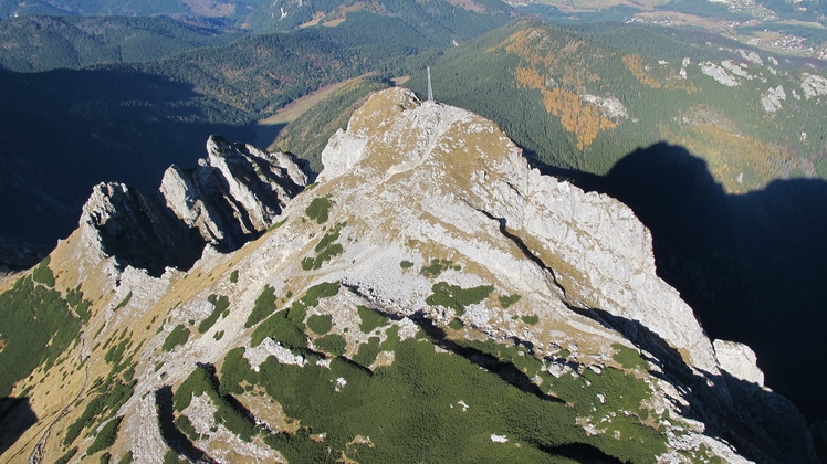
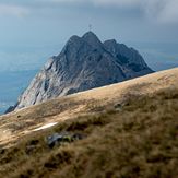
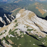
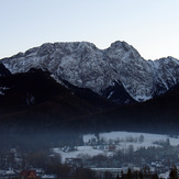
 Giewont
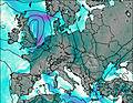
Weather Forecast, PolandIssued: 1 pm Tue 09 Jun Local TimeUpdates in: hr min sUpdate imminent
Issued: 1 pm Tue 09 Jun Local Time
Updates in:
Update imminent hr min s

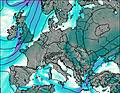
Issued: 1 pm Tue 09 Jun Local Time
Updates in:
Update imminent hr min s
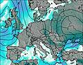
Days 1–4 Weather SummaryHeavy rain (total 30mm), heaviest during Tue night. Very mild (max 12°C on Tue afternoon, min 1°C on Fri morning). Wind will be generally light. | Days 5–7 Weather SummaryModerate rain (total 14mm) heaviest on Fri afternoon, then becoming colder with a dusting of snow on Fri night. Mild temperatures (max 6°C on Sun afternoon, min 1°C on Fri night). Wind will be generally light. | ||||||||||||||||
Tue 9 | Wednesday 10 | Thursday 11 | Friday 12 | Saturday 13 | Sunday 14 | ||||||||||||
PM | night | AM | PM | night | AM | PM | night | AM | PM | night | AM | PM | night | AM | PM | night | |
risk tstorm | heavy rain | light rain | light rain | rain shwrs | light rain | light rain | rain shwrs | rain shwrs | risk tstorm | light snow | rain shwrs | rain shwrs | rain shwrs | rain shwrs | rain shwrs | rain shwrs | |
km/h | |||||||||||||||||
 |  |  |  |  |  | ||||||||||||
— | — | — | — | — | — | — | — | — | — | 1 | — | — | — | — | — | — | |
1.8 | 14 | 1.9 | 0.6 | 6 | 1 | 0.2 | 3 | 1.5 | 6 | — | 0.7 | 3 | 0.8 | 0.3 | 2 | 1.2 | |
max °C | 12 | 10 | 7 | 9 | 9 | 4 | 6 | 4 | 2 | 3 | 2 | 3 | 4 | 4 | 5 | 6 | 4 |
min °C | 12 | 7 | 7 | 7 | 4 | 3 | 5 | 2 | 1 | 2 | 1 | 1 | 3 | 3 | 3 | 5 | 4 |
11 | 6 | 4 | 4 | 1 | -1 | 2 | -2 | -2 | -1 | -4 | -4 | -1 | -1 | 0 | 1 | 0 | |
3500 | 3300 | 3350 | 3500 | 3300 | 3150 | 2650 | 2200 | 2200 | 2250 | 2150 | 2300 | 2400 | 2500 | 2550 | 2800 | 3000 | |
Cloud base (m) | 2950 | 850 | 850 | 850 | 900 | 850 | 2050 | 900 | 1650 | 2150 | 900 | 1000 | 2000 | 2250 | 2200 | 1800 | 1650 |
— | — | 4:35 | — | — | 4:35 | — | — | 4:33 | — | — | 4:33 | — | — | 4:33 | — | — | |
— | 8:43 | — | — | 8:44 | — | — | 8:44 | — | — | 8:45 | — | — | 8:45 | — | — | 8:45 | |
Loading...
Giewont Weather (Days 0-3):
The weather forecast for Giewont is: Heavy rain (total 30mm), heaviest during Tue night. Very mild (max 12°C on Tue afternoon, min 1°C on Fri morning). Wind will be generally light.
Giewont Weather (Days 3-6):
Moderate rain (total 14mm) heaviest on Fri afternoon, then becoming colder with a dusting of snow on Fri night. Mild temperatures (max 6°C on Sun afternoon, min 1°C on Fri night). Wind will be generally light.
This table gives the weather forecast for Giewont at the specific elevation of 1909 m. Our advanced weather models allow us to provide distinct weather forecasts for several elevations of Giewont. To see the weather forecasts for the other elevations, use the tab navigation above the table. For a wider overview of the weather, consult the Weather Map of Poland.
| Weather Station | Temp. | Weather | Wind | Gusts | Cloud / Visibility |
|---|---|---|---|---|---|
PopradTatry | |||||
Chopok | |||||
* NOTE: not all weather observatories update at the same frequency which is the reason why some locations may show data from stations that are further away than known closer ones.
Giewont Photos
View all
Tatras photos (182) |
Carpathian Mountains photos (359) |
photos from mountains in Poland (290) |
all photos
 Upload new photo
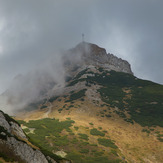


 See 12 more Giewont photos
Giewont
Giewont Tatry
Giewont
Giewont
Giewont
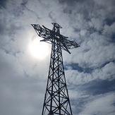
Krzyż w słońcu