Callaqui

22 Sep 2012


Skogstad Outdoor Clothing
Site Update (May 1st 2013): All weather maps have been improved to make them much more useful for climbers. Animate either temperature or weather and move your cursor to any mountain location to see how the weather is forecast to evolve at various elevations. Because of the limited space on these large region maps, we can only show this at a subset of locations. We will add much more detailed maps very soon.

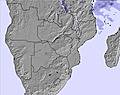
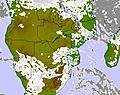
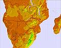
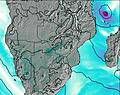
Malawi Mountain Weather Forecast Maps

Four times a day, we generate maps of more than a dozen types. The following four are especially relevant for mountain climbers. Click to zoom and see all forecast periods:

Malawi precipitation map

Rain / Snow
Map

Malawi cloud map

Cloud
Map

Malawi temperature map

Temperature
Map

Malawi wind map

Wind Speed
and Direction

Alternatively, use our animated weather map of Malawi where you can toggle all these and more layers. Animated maps also display mountain peak locations!


  • Weather-Forecast logo
  • Snow-Forecast logo
  • Surf-Forecast logo
  • Tide-Forecast logo

Company

Explore

Social